BANKA DISTRICT
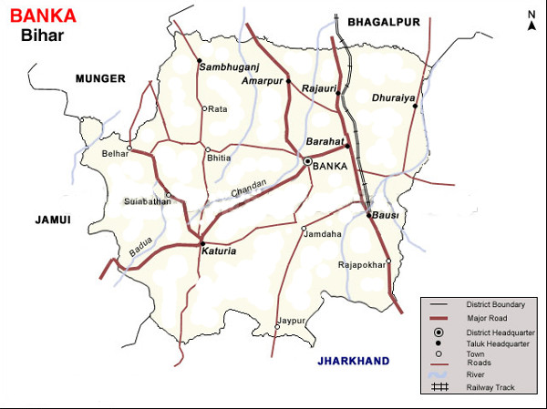 The district head quarter of Banka is situated in Banka town. The district has been established on 21st, February, 1991. Earlier it was a Sub-Division of a the district Bhagalpur.Banka is the land of great revolutionary Satish Prasad jha. He was one of the seven martyrs who hoisted Tiranga on Secretariate building of patna on 11 August 1942.satish prasad jha born on Khadihara near dhakamod of Banka.Out of 11 Blocks 9 are Naxal affected.
How To Reach
By Airport :-
The nearby airports are in – Ranchi, Gaya, Patna and Kolkata
By Rail :-
Banka lies on the broad gauge Loop line of the East Central railway under Bhagalpur Division,
By Road :-
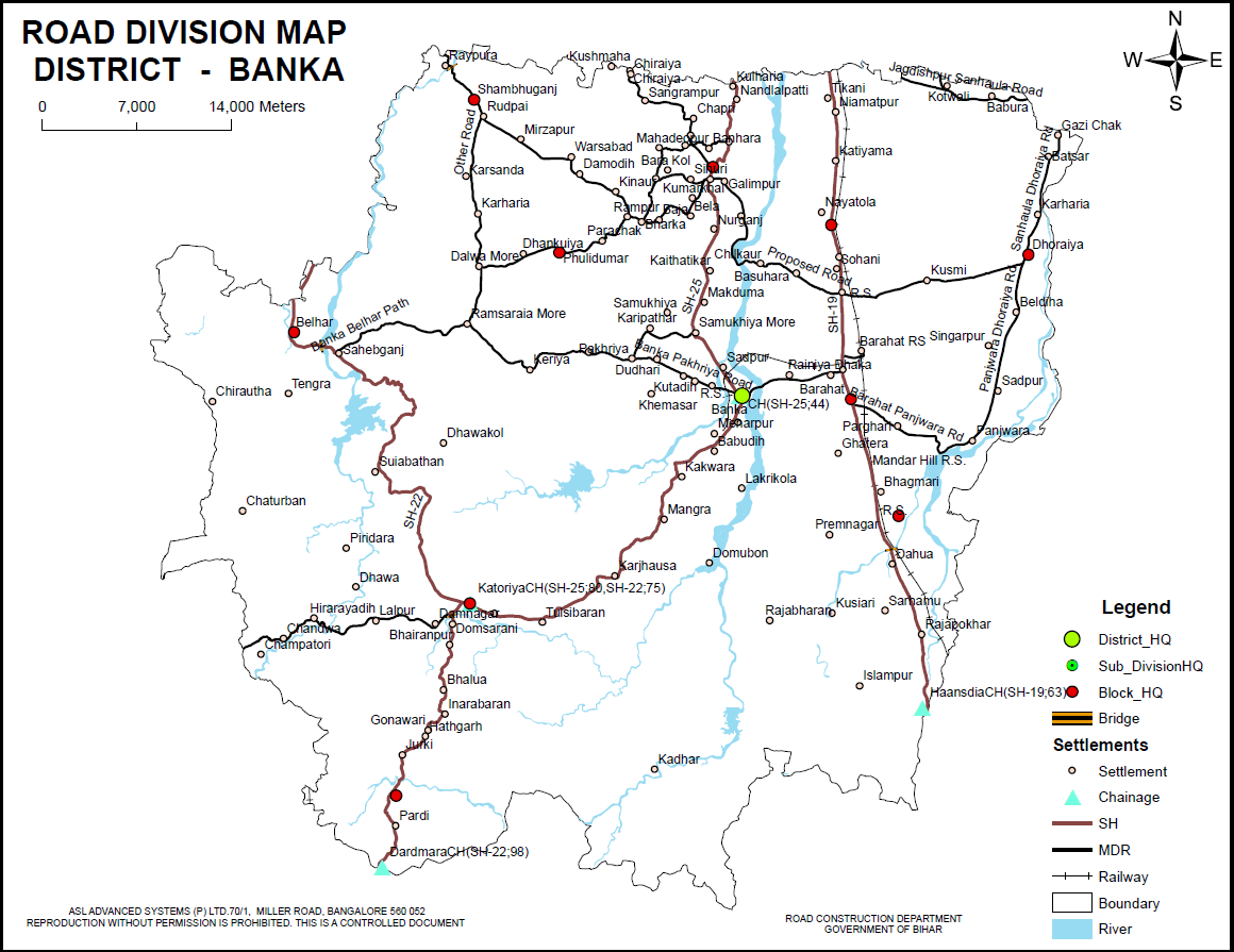 Well connected to other city through State Highway-19,22,25 other road- Banka Belhar Path,Panjwara Dhoraiya road. Barahat Panjwara road, Sanhaula Dhoraiya road, Banka Pakhriya road, Jagdishpur Sanhaula Road
Banka is 250 km From Patna.
Popular tourist destinations
Shravani Mela:- In the month of Shravan ( July- Aug ) Lakhs of Pilgrims ( Kamaria ) travel from Sultanganj to Deoghar on barefoot carrying Ganga Jal (water from the Uttarbahini Ganges ) to offer on Lord Shiva. The Distance is 105 Kms of which 64 Kms lie under Banka District of three Blocks, Belhar, Katoria and Chandan. The Scene on the road is like a fair for one month.The whole administration becomes busy for the welfare of Kamaria’s safety ( Medical aid, Traffic Police water supply sanitary and electricity etc.). Now a day Bihar Goverment has devloped the kawaria path with adding stortest route . Behind the Kamaria path following important places where we stay for rest or night halt have come:
Sultanganj (Bhagalpur Distt)
Jagdari:- Shop holder provide selter.
Kamrain Arazi:- Shop holder provide selter
Rahmatpur:- Shop holder provide selter
Asarganj Shahkund Rd crossing:- Shop holder provide selter
Asarganj Shambhuganj Rd crossing:- College building provide selter, Gov. provide temp. camp selter also Shop holder provide selter.
Goga chak:- Shop holder provide selter
Dhoba road crossing:- Shop holder provide selter
Teldhiya road crossing:- Shop holder provide selter
Manimore:- Gov. Dharmshala, Shop holder provide selter.
Kumarsar :- Gov. Dharmshala, Pvt. Dharmshala, Shop holder provide selter.
Katoria:-
Kamrriya:-
Vishwakarma Tola :-
Mahadevnagar :-
Chandannagar :-
Jalabiya more :-
Tegeshwarnath :-
Suiya
Sheolock :-
Abrakhiaya :-
Dulisar :-
Lachmanjhula :-
Indrabaran:-
The village is situated at distance of Block headquarters at Katoriya on Katoriya- Deoghar Road. It has rest houses (Dharamshalas) for pilgrims who travel on foot in large number from Sultanganj to Deoghar.
Goriari :-
Pataniya :-
Dumma :-
BANKA BLOCK
Taramandir (Babutola) :- There is a very famous temple of Mata Tara (Goddess Kali) in Babutola, Banka at the bank of River Odhani.This temple has a tube well which drawn a sweet water which is useful for stomach disease, this water is also famous in all over the state.
Panchmukhi Hanuman Temple :- In the Temple three has 60ft high Lord Shiva Idol.
Kaliya Mahdeva (Banka) :-
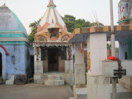
Barahat (Banka) :- During the course of exploration under village to village survey done by ASI in year 1992-93, a temple with image of Siva-Parvatiy, Surya, Vishnu, Ganesa and Hanuman etc was found.
Karharia Durga Mandir:-
Baba Bhaiharan Nath Mandir:-
Chandan Reservoir :-
Chandan, Belasi Irrigation Scheme ( Banka) :-
Orhni Reservoir Irrigation Project( Banka Fullidumer):-
BELHAR BLOCK
Kumrail :- During the course of exploration done by ASI in year 1983-84, brought to light of an site , yielding black ware and red ware. Gawachalk :- During the course of exploration done by ASI in year 1983-84 brought to light of an site , yielding black ware and red ware.
KATORIYA BLOCK
Lachhmipur fort :- The village is situated about 29 kms South- East of Block headquaters at Katoria on the river Chandan. It is noted as the erstwhile seat of the Rajas Lachhimipur, ruins of whose forts still exist.
Tangesar :- During the course of exploration under village to village survey done by ASI in year 1986-87, brought to light of an archeological site , ancient mound with yielding grey and brown pot sherds.
Laxmipur:- As per exploration done by KP Jayaswal Research Institute marked Period of site as Early medieval.
BARAHAT BLOCK
Chandi Dih:- As per exploration done by KP Jayaswal Research Institute marked Period of site as Medieval. Sabalpur:- As per exploration done by KP Jayaswal Research Institute marked Period of site as Early medieval. Azad Nagar:- As per exploration done by KP Jayaswal Research Institute marked Period of site as Early medieval. Matdiha:- As per exploration done by KP Jayaswal Research Institute marked Period of site as Early medieval. Shivnagar:- As per exploration done by KP Jayaswal Research Institute marked Period of site as Early medieval.
Baba Labokhar nath (Kuseshwar nath) Mandir (Labokhar):- During the course of exploration under village to village survey done by ASI in year 1993-94, discovered the site of archeological importance of group of three temples dedicated to Siva, Parvati and Kali.
BAUSI BLOCK
Bounsi Mela :- Every year in January, Bounsi Mela is organised, which depicts the village life of the Mandar region. The fair starts from 14th January ( Makar Sankranti day ) every year and continues for a month.
A Ratha-Yatra procession of Lord Madhusudana occurs every year on the same day as the Rath Yatra procession in Puri. Fourteenth-century Vaishnava saint Chaitanya Mahaprabhu started this Rath Yatra during his visit to Mandar.
Mandar Hills ( Mandar Parwat ):-
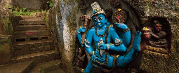
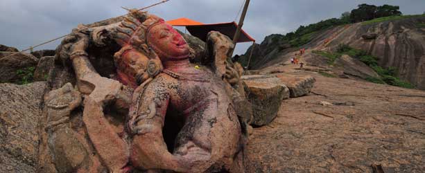
Mandar Hill ( Mandar Parwat ) is situated 30 km south from Bhagalpur, about 5 kms north of Baunsi and about 48 Km east-north from the Banka District Head quarter. The hill is about 700-ft high that consists of a huge mass of granite overgrown near the summit with low jungle. Mandar Hill is well known for its mythological background. Mandar is associated with‘Samudra-Manthan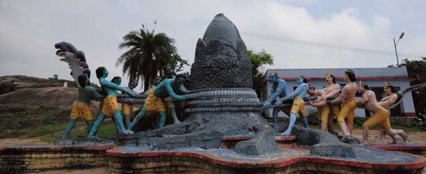 ’ which presents that the hill was used by the gods to churn the ocean to procure amrit. The serpent, Vasuki Naga offered to serve as the rope and has left behind an impression of the coil on the granite hill. According to the legends, Panchjanya – the conch shell used in Mahabharata War – was also discovered here, in the Sankh Kund. Mandar Hill is equally honored by the Jains who believe that their 12th Tirthankara attained nirvana on its peak. The puranas refer to various sacred places on the hill which is also believed to be the abode of Vishnu under the title of Madhusudana or the destroyer of a demon called Madhu who was killed by Vishnu and then covered by the Mandar hill. Kalidasa’s kumarasambhava refers to foot marks of Vishnu on the slopes of Mandar. Apart from the mythological significance, the hill is also famous for rock cut sculptures, describing various Brahmanical images.
 The hill is fully fill with relics of bygone ages.On the hill there are many kunds ( Small Tank) ).
Sankh kund(Conch pond):- This is a pond in shape of a conch shankh or mollusk. There is a big stone cut conch at the bottom. The weight of the conch is about 600 maunds ie about 6225 kg. During the dry spell of 1920-25 and 1985 when the pond got completely dried the gigantic conch was seen by the people. It said that Lord Shiva took the halahal poison received by churning the sea by this conch keeping the effect upto his neck causing neck becoming blue and his one name becoming Nil kanth. It is also conjectured that it may be the conch of Lord Vishnu which is called Panch janya conch.
Akash Ganga kund :- It is located on the Mandar hill.
Sita Kund :- It is also situated on the Mandar hill. Sita Kund has been named after goddess Sita as she is believed to have taken bath here .It is also said that at this place Sita had performed Chhath Puja.
Ram Kund(Gaya Kund) :- It is situated on the top of hill. It is said that Sri Ram Chandra did shradh ceremony of his ancestors here.
Narasimha Temple (Lakshmi Narayan Mandir) :-
 Narasimha, one of the incarnation of god Vishnu , Temple is situated at the top of Mandar Hill , which is surrounded by Paapharini Kund. The management of the Narsimha Temple is under a trust.Legend says the two demon brothers
 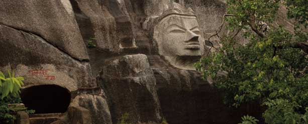 Madhu and Kaitav were born out of the ear of Lord Vishnu and both were killed by him.The head of Madhu demon made up of hard stone is situated near Narsimha temple.
Digamber Jain Tirthanakar :-
At the top of Mandar Hill is Digamber Jain Tirthankar temple.The priest of the Jain Temple claimed that the 12th Teerthankar Bhagwan Vasupujya got salvation at Mandaar Hill. His foot marks of 2000 years old have been conserved here. the architecture of this temple represents that of the Mughal era. Made of red stone which is the colour of Mandar Hill.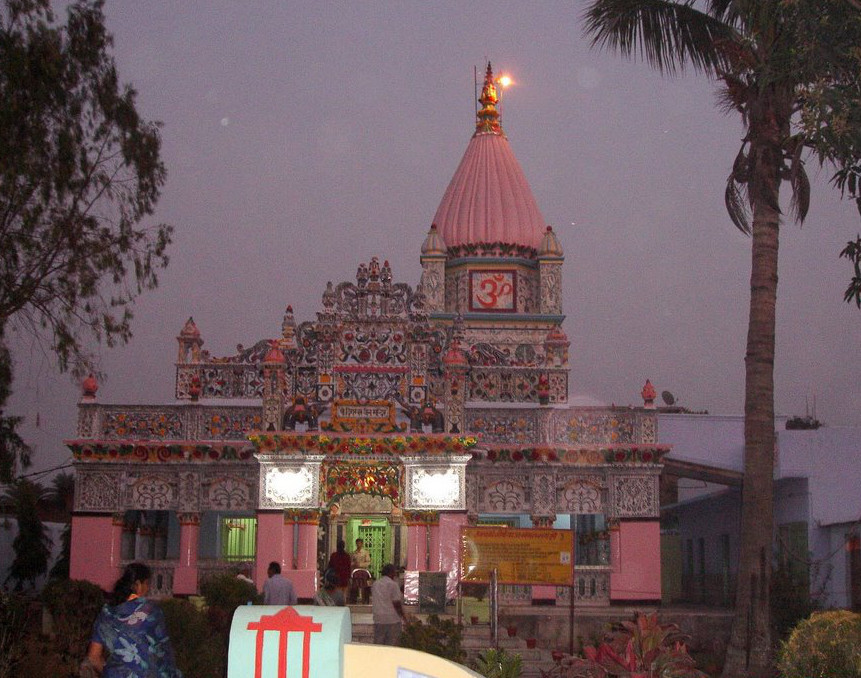
Dig. Jain Dharmshala :- In front of Mandar Hill railway station in Dig. Jain Dharmshala (Guest House), there is a very beautiful Jain temple decorated by the work of glass and sculptor. This temple with high pinnacles has an attractive Coral Colored idol of Lord Vasupoojya in cross legged seating posture.
Place of salvation:- It is said that near the place of salvation Vasupoojya attained Kevalgyan (supernatural knowledge). It is from Dharamshala, towards Hill at 500 Meters distance. Here is a beautiful temple, unique example of architectural art, has an idol of white stone of Lord Vasupoojya Swami. Three pairs of ancient feet images are installed here.
Cave temple:- Near the place of salvation, a beautiful cave temple with 5 feet high standing idol is also viewable.
Trisira temple:- This temples has a broken statue of three headed Mahakala vairo locally called trisira (three head).
Avantika Nath Temple :- The very old Avantika Nath temple,which guides to understands Nath Community, is situated at the bottom of Mandar Parvat . The Avantika Nath temple trust founded by late Babu Biro Singh of the village Sabalpur , looks after the Avantika Nath temple.
Remains of Lakh Dipa temple:- It is in north of the Vidyapith. It still preserves signs of hundreds of wall cavities for burning lamps(diya). In the past one lakh deep was used to light here. One Deep was brought from every house. The area was well Known as Balisha at that time. According to Balisha Puranas this was “Sidh Peeth of Lord Shiva”.
Paapharni Pond :-.
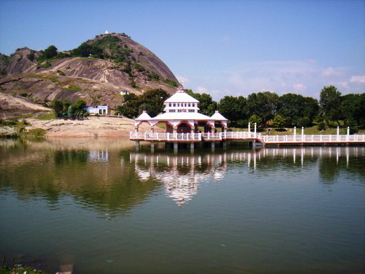 At the foot of the hill there is a tank called Paapharni.It is belived that the water of Paapharni Pond is so pure that one bath makes you free from all disease. From the vicinity of the tank three routes lead to the top of the hill.In the middle of Papharni Tank, Mahavishnu, Mahalaxmi marvelous temple has been built. Maa Laxmi temple is built in front of Paapharni Pond. Recently a Lakshminarayan Temple was built in the center of Paapharni through the contributions of local people.At the foot of the hill there are also a number of ruined temples.The priest of Vishnu Temple, says that in the seventh century, King Aditya Sen of the Chola dynasty was infected with leprosy and his disease was cured with the waters of this kunda. From then it was called Paapharni Kund. In ancient times it was small but Maharani Sona Devi, wife of King Aditya Sen, very pleased over this kunda, got it expanded and made larger.
Chaitanya Mahaprabhu Stay platform:- It is also situated near Vidyapith. It is said that Chaitanya Mahaprabhu while on way to Gaya in 1505 was indisposed and stayed here for three days and got cured. There is a marble plate inscribed like –Kalabya Sarsunya Satre Nigme, Mandar Namachale Sri Chaitanye Dayanidhe:Padyugm Bhakt Charchitam Sambhawe.
Mandar Vidyapith :- There was an old university known as Mandar Vidyapith.It is established by the late Shri Harivallabh Narayan Singh a famous social reformer , a freedom fighter and a land lord of village Azad Nagar, Sabalpur. The first president of the Indian Republic Deshratna Dr. Rajendra Prasad was the founder President and late Dr. Anugraha Narayan Singh was the first working President of the reputed Mandar Vidyapith . While a south Indian Late A.S Madhavan was the first Acharya of the Vidyapith . One English medium secondary school known as Adwat Mission is being run inside the campus of Mandar Vidyapeeth.
Madhusudan Math :- It is said, at the time of rath yatra lord Madhusudan is brought on elephant and after taking bath in the Puskarni kund. He is worshiped at this math .
Lakhpura Kali (Lakhpura):- It is located 2 km from Mandar Parbat. Lakhpura village is famous for its temple of Kali literally called Lakhpura Kali.
Chilkora (Baunsi):- During the course of exploration under village to village survey done by ASI in year 1991-92, old temple with black stone image of Siva Parvati and Hanuman was found.
Belwa :- It is situated about 8 km south of Bausi . It has remains of ancient building and some stone images of Lord Siva and Goddes Sarswati. Annual fair is held on the occasion of Basant Panchmi.
Laxmipur Reservoir ( Bounsi):- This dam was constructed on river Chandan during late sixties by the Irrigation Department, Govt of Bihar.
Bausi:- As per exploration done by KP Jayaswal Research Institute marked Period of site as Early medieval. Khangar:- As per exploration done by KP Jayaswal Research Institute marked Period of site as Late medieval. Birnian:- As per exploration done by KP Jayaswal Research Institute marked Period of site as Medieval. Bhurkuria pahari:- As per exploration done by KP Jayaswal Research Institute marked Period of site as Mesolithic. Kasawa Mandar (Mandar hill):- As per exploration done by KP Jayaswal Research Institute marked Period of site as Early medieval. Kazi Kairi:- As per exploration done by KP Jayaswal Research Institute marked Period of site as Medieval. Bhaljor:– As per exploration done by KP Jayaswal Research Institute marked Period of site as Early medieval. Kadama Pahari (Kanijoria):– As per exploration done by KP Jayaswal Research Institute marked Period of site as Mesolithic. Dhawakura (Rangsa Pahari):- As per exploration done by KP Jayaswal Research Institute marked Period of site as Mesolithic. Kainrwar Pahari:- As per exploration done by KP Jayaswal Research Institute marked Period of site as Mesolithic. Chilkara Pahari:- As per exploration done by KP Jayaswal Research Institute marked Period of site as Mesolithic. Devi Kainri:- As per exploration done by KP Jayaswal Research Institute marked Period of site as Medieval. Shiva Temple Kainri Nath:- As per exploration done by KP Jayaswal Research Institute marked Period of site as Early medieval. Sikandar pur:– As per exploration done by KP Jayaswal Research Institute marked Period of site as Early medieval. Kumar Bhag:- As per exploration done by KP Jayaswal Research Institute marked Period of site as Medieval. Kankurnath Chilkara:- As per exploration done by KP Jayaswal Research Institute marked Period of site as Early medieval. Pahalu Pahari (Bhaga):- As per exploration done by KP Jayaswal Research Institute marked Period of site as Mesolithic. Mali Pahari (Ratansar):–As per exploration done by KP Jayaswal Research Institute marked Period of site as Mesolithic.
Raja-Pokhar, Bhajore and Rajdot :- Palaeoliths were found at this place in Mali-Pahar by ASI in year 1960-61.
Madhusudan Temple( Panda Tola, Bausi):- It is located 5 km south of Mandar parvat . It is believed that Lord Ram had himself established Lord Madhusudan in this temple.This temple was built during the fourteenth century A.D. It is an important religious place for the Hindus. A large fair is held around the temple on the occasion of Makar Sankranti for a month.The present large temple was constructed during Jahangir Period.
According to Jayaswal Research Institute Archaeological Explorations this site belongs to Early medieval period.
Rajapokhar :- The department of Ancient Indian History and Archaeology, Patna University has done exploration in year 1963-64, found microliths of the geometric type at this place.
AMARPUR BLOCK
Amarpur:-The village amarpur is situated about 19 Kms. away from Banka on Banka Shambhuganj Road in Amarpur Block. It is at a distance of 26 Kms from Bhagalpur on Bhagalpur Kajraili Road. According to local tradition, the village was formed by Shah Umar Vajir of Shah Suja, the Governor of Bihar. He rehabilitated the persons who left village Patwai when is was croded by the river Chandan.
Banhara:- The village is situated just west of Amarpur. According to local tradition, Shah Suja, who was the governor of Bengal and Bihar during the period of the Mughal Emper or Shah Jehan, had his headquarter in the village.
Remains of Stupas (Dumrawan,Durian):- The village is located at a distance of a 3 Kms from the block Headquarter Amarpur, on the road to Bhagalpur. Remains of Stupas are believed to indicate the existence of Budhist Monasteries here in the remote past. According to the local tradition, the village was the seat of Khetauri chiefs, the last of whom was king Debai, who had built fort in the villages surrounded by two moats.
Jyestha Gour Math:-
The place is situated on the left bank of the River Chandan, 2 kms east of Amarpur – Banka Road. It is situated at the foot of a hillock, known as Jesthagour Pahar, on the western bank of river Chandan. The Jyestha Gour math, a place of great religious importance for the Hindus has a Shiva temple (Jyestha Gour Nath). According to Indian Mythology, Jyeshta Gour Nath is the oldest Jyotirlingas in India.
Dakshineshwar Kaali:- On the top of the hillock which is known as Jestha Gour Pahar, there is a temple of Kali and also an ancient well. A large fair is held around the temple on the occasion of Shivratri.
SAMBHUGUNJ BLOCK
Chuteshwar Nath temple :- The village is about 8 Kms away from the headquarters. There is a hill in the village containing a temple of Chuteshwar Nath. There is a large cave in the hill. Traces of marks left by chariot wheels of stones are said to indicate that a big battle was fought here in the remote past.
Asauta Garh:- The village is said to have been established by Maharani Chandarjoti after she left Kharagpur. The Maharani built a Garh ( fort) and a tank at Asauta. She also built a mosque for her son. The ruins of the Garh and mosque still exist.
Shiv temple(Gouripur):- This is about 3 kms away from village Asauta in Sambhuganj Block. A Shiv temple constructed by Maharani Chandarjoti of Kharakpur lies in this village.
Mata Durga(Karharia):- There is a very famous temple of Mata Durga or kali in Karharia.
RAJOUN BLOCK
Temples of goddesses Kali and Durga(Rupsa):- It is an ancient village in Rajoun block, situated about 6 kms west of Bhagalpur –Dumka Road, on the eastern bank of the river Chandan. Large fairs are held on the occasion of Kali Puja and Durga Puja.
Punsia Durga Mandir :-
DHURAIYA BLOCK
Shiv Temple(Dhuraiya):-The village is located at a distance of about 10 kms from Tekari Railway Station. It is noted for its Shiv Temple. A large fair is held on the occasion of Shivratri.
Kurmahat :-The department of Ancient Indian History and Archaeology, Patna University has done exploration in year 1963-64, found microliths of the geometric type at this place.
UNKNOW BLOCK
Dhala Taur :-
The department of Ancient Indian History and Archaeology, Patna University has done exploration in year 1963-64, found microliths of the geometric type at this place.
Hainchula :-
The department of Ancient Indian History and Archaeology, Patna University has done exploration in year 1963-64, found microliths of the geometric type at this place.
Lagba :-
The department of Ancient Indian History and Archaeology, Patna University has done exploration in year 1963-64, found microliths of the geometric type, sherbs of the black- and- red were at this place.
Manhatikar Mandir,Samukhiya
Maa Shyama Kaali Mandir ,Samukhiya