It was established in 1870 as a subdivision of Munger District. In 1972, it was given district status. The name of the district apparently comes from “Begum” (queen)+ “Sarai” (inn). “Begum” of Bhagalpur used to come to the “Simaria Ghat” (holy place at Ganges bank) for a month of pilgrimage which later took the present slang form Begusarai.
How To Reach
By Air:-
Patna airport which is about 130 km is the nearest airport.
By Rail
Begusarai (BGS) is Located in Sonepur Division of East Central Railway .
By Road :-
Well connected to other city through National Highway-28,31 SH-55 other road-Manjhaul Bakhri Road, Munger Ghat Rashidpur Road, Malipur Daulatpur Road, Manjhaul Garhpura Road, Begusarai Samho Road, Coal Board Road, Teghra Mubarakpur Road
Popular tourist destinations
BEGUSARAI BLOCK
Begusarai:- The KP Jayaswal Research Institute, during in the course of its Archaeological Explorations brought to light the site period Medieval.
The KP Jayaswal Radha Krishna Chaudhary Memorial Archaeological Museum :– It is situated on the local G D College premises. It has on display many statues and artifacts found during various archaeological excavations.
Begusari Museum :-It was established in the year 1981 situated at Lohia Nagar. The main collection of this museum consists of some very impressive stone sculptures and coins of Pal period. It also preserved the artifacts and art- objects collected within and the adjoining area of Begusarai district.
Kali Sthan Mandir:- This is most famous temple of Begusarai hence there after that the chowk is named after it. There is a Shiv Mandir behind this temple.
Dinkar Bhawan :- Famous Hindi poet, Rashtrakavi Ramdhari Singh Dinkar, belonged to Simaria village in the district. There’s a bust of the poet installed in the village to commemorate his contributions to the Hindi literature. The Dinkar Jayanti Samaroh Samiti, of which the Begusarai district magistrate is the ex-officio head, organises a Dinkar anniversary function at the Dinkar Bhawan in Begusarai town every year on September 23. Literary doyens of Hindi from across the country attend the function at which two Hindi litterateurs are feted.
Subash Park :-
Baidyanath Temple :- Shiva temple is built during the late Pratihara dynasty.
Chitragupta Temple:- It is situated about 1/2 KM South from Begusarai Railway Station.near Bari pokhar, Kachahari road. A black stone Four Handed Sculpture of size 37 cm x 65 cm of Late Pala period is enshrined, which Left hand upper position has a Book and Lower position hand has a Ink Pot similarly Right hand upper position has a Katar and Lower position hand has a Pen.
Kola Chaur:- The Kola Chaur is a vast area of almost 10 kms. East-West and 9 kms North-South expansion. The topology is remarkable. The slope is towards East. The old bed of Devaki (deoki) river is alive here with a channel (almost dried normally) from the north of Maharathpur, Fatehpur, Laruara, Sikandarpur and Sankh. The river bed is apparent and contains water for not less than half a year near Sankh, Taraiya, Tulsipur and Kaith-Baraith. This river bed can be seen along with the Sankh-Jinedpur road. At Damdama, Sangokothi and Cheriyadih, the water confluence of the region is still alive and can be seen in the rainy seasons. Cheriyadih becomes the junction of this water confluence from where a stream runs towards south and the other towards north. There are a number of archaeological sites all around this chaur area. To its west lies Sankh, Rajaura- Sikandarpur etc.; to its north Kaith, Baraith; to its east Kusmahaut, Bodidih, Majhanpur, Chamrahadih, Sugharan etc. ; to its south Kankaul, Suza ; Masuriyadih, Manikpur, Sangokothi, Damdama and Cheriyadih lie in the central part of this chaur.
Lodipur dih:- It is located 11 KM towards East South- East from District head quarters Begusarai. It is also an important archaeological sites along the old channels nourished by the Ganges in the past.
According to Jayaswal Research Institute Archaeological Explorations this site belongs to Early medieval period.
Sughran Dih:- It is located 21 KM towards East from District head quarters Begusarai and 138 KM from State capital Patna. It is situated around the Kola chaur. It is also an important archaeological sites.
According to Jayaswal Research Institute Archaeological Explorations this site belongs to Early medieval period.
Kolhay Baba Asthan Dih:- The KP Jayaswal Research Institute, during in the course of its Archaeological Explorations brought to light the site period Early medieval. Dhabauli Dih:- The KP Jayaswal Research Institute, during in the course of its Archaeological Explorations brought to light the site period Early medieval. Masti Fatehpur:- The KP Jayaswal Research Institute, during in the course of its Archaeological Explorations brought to light the site period Early medieval.
Bodhi Dih:- It is located 15 KM towards North -East –North from District head quarters Begusarai. It is situated around the Kola chaur. A site of two mounds North 150m x 200m x 2.5m and south 100m x 100m x 3m with the stream of river Kola dividing it in two different setups. Southern on is having the population of down trodden people as the older northern mound has been evacuated some 35 – 40 years ago after a series of group clashes eventually having no population almost. The topology here also suggests it older then the findings. Archaeological findings are M Red ware, Exterior Black Interior Black type,Storage vessel, Plate, Bowl.
According to Jayaswal Research Institute Archaeological Explorations this site belongs to Early medieval period.
Manikpur:- It is located 15 KM towards North – East from District head quarters Begusarai. It is situated around the Kola chaur. The mound 200m x 100 x 2m is almost intact with scarcely distributed house holds. The road divides it into two parts. The northern one is older and lesser populated. The landscape of this part is more remarkable with Kola stream in the North. Archaeological findings are Black slipped, Burnt, Red ware, (Plain and Polished), Black (Internal) and red (external) type, Bowl, storage vessels, Heavy vessel, Plate, cook ware, Lid.
According to Jayaswal Research Institute Archaeological Explorations this site belongs to Early medieval period.
Shahpur Dih:- It is located 10 KM towards East- South- East from District head quarters Begusarai. It is also an important archaeological sites along the old channels nourished by the Ganges in the past.
According to Jayaswal Research Institute Archaeological Explorations this site belongs to Early medieval period.
Rajaura-Sikandar dih:- It is located 5 KM towards North from District head quarters Begusarai.It is situated around the Kola chaur. It is also an important archaeological sites. According to Jayaswal Research Institute Archaeological Explorations this site belongs to Early medieval period.
Pachama:- The sculptures of Chamunda is finding of archaeological excavations.
According to Jayaswal Research Institute Archaeological Explorations this site belongs to Early medieval period.
Mahamadpur:-The KP Jayaswal Research Institute, during in the course of its Archaeological Explorations brought to light the site period Medieval.
Jagiya Dih(Khamhar):- It is located 9 KM towards North from District head quarters Begusarai. It is also an important archaeological sites along the old channels nourished by the Ganges in the past. According to Jayaswal Research Institute Archaeological Explorations this site belongs to NBPW phase period.
Nauo Lakha Temple (Bishnupur):-It is located in the heart of the town in Bishnupur. It is believed that the temple was built in the 17th century by Mahanth Deer Das. In the year 1952, Mahanth Mahavir Das undertook the task of restoring and renovating the temple. This age-old temple is adorned with beautiful paintings and carvings on its walls. Nine Lakhs is the exorbitant cost of restoring and renovating of the temple so called Nauo Lakha Temple. The present temple is famous for its glittering look due to use of Makrana and Italian tiles. The temple is constructed in a large campus bearing area of 150m x 100m.
According to Jayaswal Research Institute Archaeological Explorations this site belongs to Medieval period.
Ulao dih:- It is located 6 KM towards West from District head quarters Begusarai. There is a Mound of size 100m x 100m x 2.5m. The mound is a dense habitation site. A village is situated here from hundred of years.A mosque has been built on the highest portion of the mound. The famous Ankuri Nath temple is in the east. The sculptures of Harihar along with Red ware, Red polished ware, Burnt Water jar, cookware are finding of archaeological excavations.
According to Jayaswal Research Institute Archaeological Explorations this site belongs to Early medieval period.
Radhe Shyam Temple (Ulao):- Situated 6 km west of Begusarai town on National Highway 31 at a place called Ulao Temple It is made by Shyam kumara of Ulao estate in 1857. The temple is a superb piece of Indo- Western architecture. The main temple is based on the platform of 1m height. An open ground of 34 m x 27 m is in the middle of the entrance and the main temple. It is embellished with exquisite murals of rich Rajasthan Shekhawati Art of painting. The theme of the paintings is based on the Ramayana, the Mahabharata and other Hindu epics.
Ankuri Nath Temple(Ulao): – Ankuri Nath Mahadev Panch Mandir is about 4 K.M. west from Begusarai H.Q. It is about 1.5 K.M. south from NH. – 31. At present this temple bears the Panchayatan style of architecture. The original temple made of stone is in the centre. The central temple bearing a broken Shivling seems to be made during late Rajputana Period. The rectangular plan of this central architecture is important over a platform of 5m x 2.60m x about 10m high. Four temples in each corner has been constructed somewhere in the 20th century. Formerly it was known as Ankuri Nath Simaria Mahadev.
Sanghaul dih:- It is located 5 Kms West from District head quarters Begusarai. There is a Mound of size 150m x 100m x 2.5m. The mound is a dense habitation site. It is alluvial deposit and Agricultural field in the western part. Mound is extended between N.H.-31 and railway track. The mound is situated to the south of government polytechnic college. Two black-stone sculpture of Buddha excavated (during construction) from this mound are placed in the K.P. Jayaswal Archaeological museum of G.D. college, Begusarai. Some other badly broken Pala Sculptures are placed in the Kali temple of Sanghaul Deeh. Another such sculpture of Asthanak Buddha excavated in 2004 during a personal construction work and was managed to be kept and displayed in the same above mentioned museum. It was a centre of Buddhism during Pala period. The finding of Asthanak Buddha and a votive stupa supports this opinion. Black ware, red ware, Black polished ware, Black (out side), and Red (inside) ware, Water jar, cookware, Storage Bowl.are also finding from the site.
According to Jayaswal Research Institute Archaeological Explorations this site belongs to Early medieval period.
Gopal Mandir(Sanghaul):- It is located about 5 km west from Begusarai district headquarters. Mandir lie on the Mound 50 x 40 x 15m. It is made by Manager Ram Karan Upadhyaya on behalf of the Zamindar Mrs Jayanti Kurmi of Ulao estate in year 1902. A Sanskrit school is running in the southern western Part since 1906. A goshala in the southern eastern, Dharamsala in the northern east and the temple in the central part were made. The temple is still in use. The three storied building is in advance stage of decay. An old pond is in the western side of the building. There is a secret stairway from the top floor to the eastern end of the tank.The temple used to have 31 acres of land campus but now the sign of encroachment can be seen. A black Asthadhatu sculpture of Krishna of 20th century is placed in the Garbhagriha of the temple and being offered regular worship. A Mangoesta tree is in front of the Naubatkhana. The specy is supposed to be rare in this region.
Kankaul :- It is located 2 KM towards North from District head quarters Begusarai. It is situated around the Kola chaur. Kankuaul have important archaeological sites. Here is a newly built small temple called Brama Asthan. The remarkable feature of this site is the Black stone intact Four Handed Vishnu (29 cm x 70 cm ) sculptures of Pala Period being placed here and being offered regular worship.The sculptures are supposed to be found from kankaul deeh. There are three pieces of black stone sculpture placed at this site. The low relief Vishnu sculpture is full of decoration. Garuda has been depicted in the pedestal. Lakshmi and Saraswati are in the two flanks.
In Kankaul there is a Mound 30m x 30m x 3m. Mound has been condensed to the Thakurbari place only and being offered regular worship. Dense population can be seen around the mound. The Thakurbari is said to be 150 years old. According to local residents a black stone sculpture used to be placed in the Garbhagriha of the temple ten to twenty years ago but now only ‘Shaligram’ is here and being worshiped. Archaeological findings are Red polished, Black polished, Red ware, Water jar, Dish, cooking vessels.
According to Jayaswal Research Institute Archaeological Explorations this site belongs to NBPW phase period.
Suza:- It is located 4 KM towards North District head quarters Begusarai. It is situated around the Kola chaur. It is also an important archaeological sites .
According to Jayaswal Research Institute Archaeological Explorations this site belongs to Early medieval period.
Suza Math:- This is said to be one of the 14th Century Math running in this region. Mahanth Krishna Das Payohari ji Maharaj is said to be the founder. The Naokothi estate denoted ample land to it and offered its descendent to the service of the above mentioned prist as the boy was supposed to be the blessing of this math. Later Saha Suja granted a copper plate to Mahanth Naga Baba Parshu Ram ji Maharaj. According to the villagers there used to be some Astadhatu sculpture in this Thakurbari but at present nothing remarkable except the rich tradition can be seen here.
Majhlapur:- It is located 8 KM towards East North- East from District head quarters Begusarai. It is also an important archaeological sites along the old channels nourished by the Ganges in the past.
According to Jayaswal Research Institute Archaeological Explorations this site belongs to Early medieval period.
Sankh Dih:- It is located 8 KM towards North- East from District head quarters Begusarai. It is situated around the Kola chaur. It is also an important archaeological sites.
According to Jayaswal Research Institute Archaeological Explorations this site belongs to Early medieval period.
Masooriya Dih (86° 11’ 17/25° 27’ 22”):- There is a Mound of size 150m x 200m x 5m.The landscape and topology of this site is remarkable. It is situated in the western corner of the famous kola chaur, which is created by some distributaries of river Ganges like Deoki, Koyal etc. The variety of potsherds in surface finding is enough to prove this site the oldest in the region. Some of the pot , sherds seem to be representing even Neolithic culture. Water confluence here even at present catches attention. NBP, Blackware, Red slipped, Black slipped, Red ware.Storage vessel, cookware, Bowl, Plate, Basin, Water jar etc. and vessels with thick and heavycore are finding from the site.
According to Jayaswal Research Institute Archaeological Explorations this site belongs to NBPW phase period.
Chamrahadih:– It is situated around the Kola chaur. It is also an important archaeological sites.
Sughran :- It is located 21 KM towards East from District head quarters Begusarai and 138 KM from State capital Patna. It is situated around the Kola chaur. It is also an important archaeological sites.
Damdama:- It is located 16 KM towards North- East from District head quarters Begusarai and 120 KM from State capital Patna. It is situated around the Kola chaur. It is also an important archaeological sites.
According to Jayaswal Research Institute Archaeological Explorations this site belongs to NBPW phase period.
Sango Koth:- It is located 17 KM towards North- East from District head quarters Begusarai and 121KM from State capital Patna. It is situated around the Kola chaur. It is also an important archaeological sites.
Cheriya Dih:- It is located 16 KM towards North- East from District head quarters Begusarai and 120 KM from State capital Patna. It is situated around the Kola chaur. The site is a set of two intact mounds. It has a remarkable landscape. A water channel of river Kola, a stream of Devki (Dauki) flows from the west and the main bed of Devki Passes through North. The northern mound is surrounded by water sources from three sides. A water passage towards east can be seen along with the southern mound incircling it from three sides. The habitant of the northern mound is older. The second mound around 10 acres of height 4 m, called Kamathan. In fact, the deeh used to be around Kamathan. There are two Sculpture, Kamathan Male deity ( 28cm x 36cm) and Kartikaya 20cm wide of Late Pala and Rajput period. Both sculpture are badly broken. The male deity placed under old Peepal at Kamathan is defaced and sitting in Lalitasan. Hands broken Kartikaya can be identified only by his Peacock (Mayur). Its Upper Portion is also broken. Archaeological findings are Red ware (plain & polished), Black polished burnt, Bowl, Cook ware, Plate.
According to Jayaswal Research Institute Archaeological Explorations this site belongs to Early medieval period.
Kushmaut Dih :- It is located 12 KM towards East-North- East from District head quarters Begusarai and 116 KM from State capital Patna. It is situated around the Kola Chaur. It is also an important archaeological sites. It is the Black and Red ware site.
According to Jayaswal Research Institute Archaeological Explorations this site belongs to Gupta period.
Kaith:– It is located 11 KM towards East from District head quarters Begusarai and 128 KM from State capital Patna. It is situated around the Kola chaur. It is also an important archaeological sites.
According to Jayaswal Research Institute Archaeological Explorations this site belongs to Early medieval period.
Bhairwar:- It is located 12 KM towards East from District head quarters Begusarai and 132 KM from State capital Patna. It is also an important archaeological sites along the old channels nourished by the Ganges in the past.
According to Jayaswal Research Institute Archaeological Explorations this site belongs to NBPW phase period.
Majhanpur:- It is situated 13 KM towards East from District head quarters Begusarai around the Kola chaur. It is also an important archaeological sites.
According to Jayaswal Research Institute Archaeological Explorations this site belongs to NBPW phase period.
Baraith:- It is located 3 KM towards North from District head quarters Begusarai around the Kola chaur. It is also an important archaeological sites.
Farida dih:- It is located 11 KM towards North- East from District head quarters Begusarai.
It is also an important archaeological sites along the old channels nourished by the Ganges in the past.
Hamo dih:- It is located 12 KM towards West-North- West from District head quarters Begusarai.
It is also an important archaeological sites along the old channels nourished by the Ganges in the past.
Taraiya:- It is located 9 KM towards North- East from District head quarters Begusarai.
It is also an important archaeological sites along the old channels nourished by the Ganges in the past.
BARAUNI BLOCK
Panch Mandir Barauni Refinery :- Panch Mandir, another temple situated in close proximity to the Radhe Shyam Temple, is replete with Pala-era statues of various gods and goddesses and other artifacts of the same period. The Shivalinga in the temple also belongs to the Pala period.
Park at IOC Works :- Situated 8 km west of Begusarai town near the Barauni Refinery. The park has been developed by the Barauni Refinery. The green cover given to a wide area is a major ecological relief in this industrial belt. The park is also the winter destination of a large number of migratory birds.
Sita Ram Bhawan Mandir :-
Semaria :- It is situated northern bank of River Ganges opposite of Mokameh. It is about 20 Kms from Begusarai. Huge amount of devotees assemble here for bathing in the on the Kartik and Maghi Purnima.Simaria village is also the birthplace of famous Hindi poet Ramdhari Singh Dinkar. The month-long Simaria Mela, organised on the bank of river Ganga at Simaria Ghat during October-November every year. The devotees stay in thatched houses and take a dip in the river as there’s belief that a dip in the Ganga during the period washes all sins. The atmosphere becomes supremely religious during the period, and the festivities end with Chhath festiva. The sanctity of the Ganges is unquestionable where ever it passes through but few holy- places beside it have earned more sacred identity. Simariya is one of them. The Kartika – Mela here has been recognized as State- Fair.The Kalpwas on the bank of river Ganges has been appreciated even in the “Matsya Mahapurana” ( chapter 108 ). Pilgrims from all over the Mithilanchal,West Bengal, Orissa and even from the downs of Nepal use to come here in the month long Kalpavas on the bank of Ganges. It seems that the bank of the Ganges cited in the poems of Vidyapati might be Simariya. The continuous flow of devotees from heart of Mithila to Simariya supports this assumption.
Rajendra Setu :- 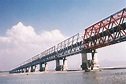 Also known as Rajendra Pul and Simaria Pul is a bridge across the River G that was the first bridge to link the northern and southern portions of the state of Bihar. The location of the bridge was based on the work of M. Visvesvaraya, who was more than 90 years old at the time.
The double track road-cum-single track rail bridge near Hathidah in Patna district was inaugurated in 1959 by Jawaharlal Nehru, Prime Minister of India and the 1st Chief Minister of Bihar Dr. Srikrishna Singh. Construction of the bridge was by Braithwaite, Burn & Jessop Construction Company. It is about 2 kilometres (1.2 mi) long and carries a two lane road and a single line railway track.
It has 14 spans of 400 ft and 4 spans of 100 ft.
Ratauli:- The KP Jayaswal Research Institute, during in the course of its Archaeological Explorations brought to light the site period Early medieval.
Sahuri:- It is located 9 KM towards North from District head quarters Begusarai, 5 KM from Barauni and 113 KM from State capital Patna. It is also an important archaeological sites along the old channels nourished by the Ganges in the past.
According to Jayaswal Research Institute Archaeological Explorations this site belongs to NBPW phase period.
Chanandih:- It is located 12 Km towards North-West from District head quarters Begusarai.
There is a Mound 225m x 175m x 8 m. At present no habitation can be seen. The inhabitational site has shifted 2 Km south. The villagers have tried to level the mound from three sides. Only the top most central part has remained intact. A 4 Km wide channel touches its western end. The topology of this site is remarkable. The streams of Chanan seem to encircle the mound. Grey ware, N.B.P. ware, Black ware, Red ware, Orangies ware, Black (inner) and Red (upper) ware, Water jar, storage vessel, Bowl, glass, cooking vessel, Tub, Plate, Lid, Single mouthed sprinkler are the Archaeological findings.
According to Jayaswal Research Institute Archaeological Explorations this site belongs to NBPW phase period.
Narsinghpur(Sograha):-It is located 16 Km from District head quarters Begusarai.There is a Mound spread in about 100 Bighas and height 3 m, covered with urban residential structures. This huge mound has been altered due to a number of urban development schemes. The southern part of this mound is bound by the railway track while the north by old Awadh- Tirhut road and in the west is the Deen Dayal Road, Barauni. The whole mound is divided in to two wards of Shokhara.The topology and the extension of the mound is remarkable. At present the river Ganga lies to the south of this site (almost 5 KM.) A current popularly known as Devaki used to emerge from Ganga and flow just east of this mound. The Awadh Tirhut Road used to pass from almost Northern foot of the mound. The height and the extension of the mound indicate the continuity of inhabitation.
Black ware, Red ware, Red polished ware, Inner red outer black ware, inner grey outer red ware, Water jar, cooking vessels and bowl are Archaeological findings.
Sograha:-According to Jayaswal Research Institute Archaeological Explorations this site belongs to Early medieval period.
Bagraha dih:-It is 1 Km. north to Sograha Deeh and towards east from Barauni. There is a Mound 100m x 75m x 2 m almost flattened due to power sub station construction and cultivation. NH28 seems to divide this mound. The old stream of Devaki would be flowing from its south. Red ware, Black ware, Black polished ware, Burnt, Outer red inner black ware, Bowl, cookware, Jar open mouth vessels are Archaeological Explorations findings.
Rajwara:- It is located 16 KM towards West from District head quarters Begusarai.There is a Mound. The mound is said to be in two parts the northern part is higher while the southern is lower. Mound is extended in more then 5 acres. Red ware, Red polished ware, Red (Oranges’) ware, Burnt ware, Rim of large cookware, water jar are the finding of the site. It is an important archaeological sites along the old channels nourished by the Ganges in the past. According to Jayaswal Research Institute Archaeological Explorations this site belongs to Early medieval period.
Marichi Stone Sculpture (Rajwara gumti):- Broken from the neck, the sculpture is at present out under a Peepal tree near Rajwara Railway crossing. The sides of the stele as well as the hands of the deity are broken {Size Width – 45cm, Height – 57cm (up to neck)}
There in an inscription in one line. Seven Varahs (Pigs) seems to drag the chariot of Devi. ‘Rahu’ has been depicted in the lower part of the platform.
Asurari Dih:- It is located 12 KM towards West from District head quarters Begusarai. There is a Mound 100m x 100m x 2.5 m. Devki, a stream of river Ganga (Dry water bed) Passes the mound. The mound has been flattened from the western and for agricultural practices. A foot path way from the Asurari Bihat hault main street bring one on this mound. The old Awadh Tirhut Road passes from almost 100 m north to this mound.
Red ware, Black polished ware, Red polished, cookware, water jar, sprinkler, sacred lamp (Deep) are the Archaeological findings.
According to Jayaswal Research Institute Archaeological Explorations this site belongs to Early medieval period.
Bihat:- It is located 17 KM towards West- South-West from District head quarters Begusarai. The population shift of Bihat is remarkable with the population flow of upper caste people from the south across the Gangas and from the Mithilanchala. The down troddens might have evacuated the place. The temples here seem to represent cultural features.
According to Jayaswal Research Institute Archaeological Explorations this site belongs to Early medieval period.
Shiv Temple (Bihat Bazar):- This is newer of the temples present here. The platform follows almost square plan of 4m x 4m with a raised height of almost 80 cm. The height of the shikhar is about 10 m. The temple seems to be around 100 years old.The temple enshrine Black Stone Basaha 15 cm x 13 cm x 7 cm. A blackstone sculpture completely defaced is also placed in the Garbhagriha.
Jageshwar Baba Temple(Bihat):- This is one o the oldest temple of Bihat. The temple with its dome shaped top is remarkable and said to be around 350 years old. The platform follows the square plan of 5m x 5mx 10 m and its height is about 10 m. The temple enshrine Black Stone Shivlinga 23 cm high and 28cm circumferance.There are two sculpture. One is completely defaced made of Black stone sculpture and other is Black stone Broken stele of 49 cm x 18 cm x 15 cm.
\Gauri – Shankar Temple(Bihat):- The 150 years old temple was renovated in 1995. The procession of Ram – Vivaha at Bihat starts from this very temple. The sculpture is newer.
Amar Das Thakurbari (Bihat):- The 250 years old Thakurbari was renovated in the year 1995-99. Built above a rectangular platform of 15m x 8m x 1m. The temple has a central courtyard.
Bhagwati Asthan(Bihat):-Three sets of structure at present can be seen here. The southern is the oldest and is said to be more than 200 years old. The landscape here is remarkable.
Chakiya:- The sculptures of Mukhalinga is finding of archaeological excavations.
According to Jayaswal Research Institute Archaeological Explorations this site belongs to Early medieval period.
BIRPUR BLOCK
Birpur((83˚05’40”/25˚31’00”):- It is situated 12 kms north from Begusarai . There is a Mound. It is a big mound. The top is intact to some extent. Agriculture practices has been done through out the years. The middle part of the mound is inhabited with market and habitation.It is one of the richest mounds of the district. Finding of lipped and collared potware of fine fabric is remarkable. Grey ware and N.B.P. ware pots indicate its richness and oldness. The Jhanjh Bridge is towards the east- north from this site. Ancient stone images of Lord Vishnu and other deities were also discovered in the bed of an old tank in 1959.
The excavation of this site conducted in 2004 by A.I.H. and Archaeological department of G.D. College, Begusarai, with the permission granted by A.S.I., brought in light the existence of six cultural sequences. The archaeological remains collected from this site seem backing up the possibilities of this place being a famous trading centre right from Kushanas to Turk Afgan.
According to Jayaswal Research Institute Archaeological Explorations this site belongs to Gupta period. The temples here seem to represent cultural features.
Sun Temple (Birpur):- It is situated about 14 KM North from Begusarai district headquarters. A temple enshrine a black stone Sculpture of size 77cm x 143cm of Pala period. Pointed stele, sparsely decorated having three figures-two of flying ganadherves on both sides on the top and the face of a tiger in middle of those celestial being, two hands holding two stalk of full flown lotus. Sun is standing on a big lotus throne bearing the relief of seven horses of the Devine chariot. The sparse decoration and the pointed Stele are one of the remarkable features of this sculpture. Crown and waist girdle are the ornaments the deity is decorated with. The flank of the stele is carved with some twisted line symbolizing the emergence of sun flames. The Deity is blanked by several divine attendants like Usha Pratysha, Dandi, Pingala, Samjana, and Mahasveta.
Bhairav Asthan(Birpur):- A fine piece of Pala sculpture of Black Stone Tara 25cm x 50cm is put in the newly built Temple and being offered prayer by the villagers as “Bhairav – Baba”. ‘Pancha Dayani’, Buddha decorated in the crown. The superb piece of antiquity is intact.
Baraipur:- The KP Jayaswal Research Institute, during in the course of its Archaeological Explorations brought to light the site period Gupta. The Mound and temples here seem to represent cultural features.
Baraipura:- The KP Jayaswal Research Institute, during in the course of its Archaeological Explorations brought to light the site period Early medieval.
Nonpur Mound (Baraipura):- It is situated 14 kms North from Begusarai. There is a Mound of size 100m x 200m x 5m. Balan stream towards North of the embankment join the mound. It is of Alluvial soil (Sand mixed). At present the mound is a dense inhabitational site. The topmost of this mound which lies in its north-west part is the residence (ancestral) of few Nonfar/Nonia caste people.Red polished, Black polished, Red (outer) and Grey (inner) Red ware, water jar, cooking vessels, Bowl are finding of the site.
Vishhar Asthan(Baraipura):- It is small temple said to be built almost 100 years ago. Here is a black stone Raivant Sculpture of Pala period of size 50 cm wide and 1 m high. Riding over highly caparisoned horse, Raivant is shown booted. Right hand of the deity is slightly raised and probably holding a cup. An attendant has been depicted holding a very big shaft of a parasol lifted over the head of Raivant. A dog is running under the belly of the horse. Upper limbs is Partially destroyed.
Chamunda Asthan(Baraipura):- It is situated 14 Kms North from Begusarai district headquarters. Temple is said to be built almost 125-150 years ago. The old temple is made of bricks jointed by surkhi lime. A black Stone of Pala Period Chamunda Devi 52cm x 1m is in the Garbha griha 4m x 4 x 8m.Two hands of the eight handed Devi are holding an elephant, Damru, vessel, dagger in three right hands which on left hand touches the lips and two other holding ’Danda’ and ‘ Munda.’ Sculpture is intact.
Basaha Asthan & Mound(Bariapura):- It is situated 14 Km North from Begusarai district headquarters.There is a Mond 140m x 112m x 4 m. The mound has a remarkable landscape having two ponds one each toward its northern and western ends. The north-west could be its peak from where one can experience the gradual sloping. The eastern part of the mound has deep cut throughout meant for leveling the agricultural land. Remains of an old dig well can be seen in this part. There is the old temple said to be built almost 125-150 years ago. The remains of a structure was found almost 1 m deep in the foundation which was ultimately covered by the villagers. A brick built temple size 7.6 X 7.6 m has been made 5 m ahead of the old one in year 1990.The significance of this temple is the black stone Surya (width 52cm, height 107cm) and Basaha(107 cm length 42 cm width, 70 cm height) Sculptures of Pala period put and being offered regular prayer in the Garvagriha of size almost 3m X 3m.The sun is highly decorated. Two handed sun is accompanied by Usha and Pratyusha in the bottom. The lord is holding Lotus in his both hands. The sculpture of Vishnu, Sun, Basaha, Chamunda and Shiva Ling, found from or around this mound.
Other Archaeological findings from the Mound are Red ware, Oranges ware, (Pots herds) only.Water jar, cooking vessel, Plate, Bowl, thick storage vessel.
Naula Dih (25°33’17″N 86°3’51″E):- It is situated in village Naula about 20 km North –East from Begusarai district head quarters and 4 km west of the Birpur Block headquarter on the Begusarai-Birpur road. There is a Mound. The mound is almost intact. The expansion and landscape is remarkable. The road intersects the mound in two parts. The remains of fortifications had been explored and surveyed in 1950-52 by A.I.H.Culture and Archaeology department of G. D. College, Begusarai. The Northern mound is remarkable for its landscape with natural and man – made water channels. In the course of excavations findings are Pottery – N.B.P., Black slipped, Burnt (Plain & Polished), Red ware (Plain & Polished), Internal Black & External Red type, Vessels – Heavy type storage vessel, water jar, Dish, cookware, small and large Plate, bowl, Deep Pan, Flat pan, a black stone broken sculptures with inscription of Vigraha Pala III.
A local resident Shri Arvind Prasad Singh, who owns most of the main mound part donated coins and the antique collection from this mound to the museum of G. D. College, Begusarai. A black stone broken sculptures with inscription of Vigraha Pala III has been displayed in the K.P.J.A. Museum of the A.I.H. Archaeology Deptt., G. D. College, Begusarai. It was an important centre of art, culture and administration during the Pala period. There are evidences of continued history of the place since as early as the Mauryan period.
Gopalpur:- The KP Jayaswal Research Institute, during in the course of its Archaeological Explorations brought to light the site period Early medieval. Makhwa:- The KP Jayaswal Research Institute, during in the course of its Archaeological Explorations brought to light the site period Early medieval. Muzaffara Dih (Karim Tola):- The KP Jayaswal Research Institute, during in the course of its Archaeological Explorations brought to light the site period NBPW phase. Dihpur:- The KP Jayaswal Research Institute, during in the course of its Archaeological Explorations brought to light the site period Early medieval. Khaptahi (Badaiyar):- The KP Jayaswal Research Institute, during in the course of its Archaeological Explorations brought to light the site period Kushan
Chamar Dih(Gopalpur):-It is situated about 25Kms North West from Begusarai district headquarters.There is a Mound – 200m x 150m x 1.5m. Archaeological findings from the Mound are Gray ware, Black sliped, Red ware. Dish, Blow, cookware.
According to Jayaswal Research Institute Archaeological Explorations this site belongs to NBPW phase p[eriod.
Jagadar Dih:- The KP Jayaswal Research Institute, during in the course of its Archaeological Explorations brought to light the site period Early medieval. Garihuather:-The KP Jayaswal Research Institute, during in the course of its Archaeological Explorations brought to light the site period Early medieval. Baracol:- The KP Jayaswal Research Institute, during in the course of its Archaeological Explorations brought to light the site period Early medieval.
MANSURCHAK BLOCK
Agapur Dih:-The KP Jayaswal Research Institute, during in the course of its Archaeological Explorations brought to light the site period Early medieval.
Agarpur Takiya:- It is situated about 38 KM North West from Begusarai district headquarters. There is a Mound of size 300m x 100m x 1m.There are Cultivation and Residential Building on the mound. Red Ware, Red slipped ware, Dish, Cooking Vessel, are the finding of the site.
According to Jayaswal Research Institute Archaeological Explorations this site belongs to Early medieval period.
Samsa:- The KP Jayaswal Research Institute, during in the course of its Archaeological Explorations brought to light the site period Early medieval.
Bhawanipur Dih:- It is situated about 42 KM North West from Begusarai district headquarters.Threr is a Mound os size 200m x 300m x 1m., on which a temple is established.The mound is used in Cultivation and for Residential building. Red Ware, Dish, Bowl, Cookware, Pane, Jar, Heavy vessel for grain storage etc Tub (large open mouthed vessel).are the finding of the site.
According to Jayaswal Research Institute Archaeological Explorations this site belongs to Early medieval period.
Gorapur:– The KP Jayaswal Research Institute, during in the course of its Archaeological Explorations brought to light the site period Early medieval. Ahiapur Dih:- The KP Jayaswal Research Institute, during in the course of its Archaeological Explorations brought to light the site period Early medieval. Dasharathpur Dih:- The KP Jayaswal Research Institute, during in the course of its Archaeological Explorations brought to light the site period Early medieval. Gobindpur Kothi:- The KP Jayaswal Research Institute, during in the course of its Archaeological Explorations brought to light the site period Early medieval. Kastoli:- The KP Jayaswal Research Institute, during in the course of its Archaeological Explorations brought to light the site period Early medieval. Salampur Dih:- The KP Jayaswal Research Institute, during in the course of its Archaeological Explorations brought to light the site period Early medieval. Naipur:- The KP Jayaswal Research Institute, during in the course of its Archaeological Explorations brought to light the site period Early medieval. Bahrampur:- The KP Jayaswal Research Institute, during in the course of its Archaeological Explorations brought to light the site period Early medieval. Mohanpur Dih (Temuha):- The KP Jayaswal Research Institute, during in the course of its Archaeological Explorations brought to light the site period Early medieval. Gorapur Dih:- The KP Jayaswal Research Institute, during in the course of its Archaeological Explorations brought to light the site period Early medieval.
BACHHWARA BLOCK
Jhamtia Ghat :- It is situated 2 km west of Bachhwara on bank of Ganga.Devotees of Lord Shiva, who offer of the Ganges water in the Shiva Temple at Vidyapati Dham, collect the sacred water here. A large fair is held on these occasion. Chiranjipur Dih:- The KP Jayaswal Research Institute, during in the course of its Archaeological Explorations brought to light the site period Early medieval. Chamraha Dih(Fateha):- The KP Jayaswal Research Institute, during in the course of its Archaeological Explorations brought to light the site period Early medieval.
Majhos Dih:- It is situated about 30Kms North – West from Begusarai district headquarters. There is a Mound of size 200m x 200m x 2m. Archaeological findings from the Mound are Red ware, Outer black, inner Red ware, Deep bowl, Bowl, cookware.
According to Jayaswal Research Institute Archaeological Explorations this site belongs to Early medieval period.
Bharaul Dih:- It is located 18 KM towards East from District head quarters Begusarai and 138 KM from State capital Patna. There ia Mound of size 300m x 250m x 1.5m. Archaeological findings from the Mound are Red ware Black, Polished, Bowl, Plate, Storage vessels, cook ware, Deep Bowl, Dish.
According to Jayaswal Research Institute Archaeological Explorations this site belongs to NBPW phase period.
Bhikam chak Dih:-The KP Jayaswal Research Institute, during in the course of its Archaeological Explorations brought to light the site period Early medieval.
Rajapur Dih:- The KP Jayaswal Research Institute, during in the course of its Archaeological Explorations brought to light the site period Early medieval.
Chilawa Dih:– It is located about 33 K.M. North – West from Begusarai district headquarters.
There is a Mound 500m x 300m x 2m. Archaeological findings from the Mound are Red ware, Black polished gray ware,Water bowl, Dish, storage vessels, cookware.
According to Jayaswal Research Institute Archaeological Explorations this site belongs to Early medieval period.
Rasidpur Dih:- It is situated 10km away from sub-district headquarter Bachhwara and 46km away from district headquarter Begusarai.There is a Mound of 400m x 200m x 2m. Archaeological findings from the Mound are Red ware, Black ware, Black polished ware.
Bowl, Plate, Pan.
According to Jayaswal Research Institute Archaeological Explorations this site belongs to Early medieval period.
Rudauli Dih:- It is located around 32 Kms North-Eest from Begusarai district headquarters.
A Mound of 200m x 125m x 3m. size found here. Archaeological findings from the Mound are Red ware, Pan, Plate, Bowl, Storage vessels.
According to Jayaswal Research Institute Archaeological Explorations this site belongs to Early medieval period.
Arwa Dih:- The KP Jayaswal Research Institute, during in the course of its Archaeological Explorations brought to light the site period NBPW phase. Bachhwara Dih:- The KP Jayaswal Research Institute, during in the course of its Archaeological Explorations brought to light the site period Early medieval. Maranchi Dih:– The KP Jayaswal Research Institute, during in the course of its Archaeological Explorations brought to light the site period Early medieval.
CHHORAHI BLOCK
Baraipura:- It is situated 8km away from Chhorahi block headquarter and 50km away from district headquarter Begusarai. The sculptures of Chamunda is finding of archaeological excavations.
Narayanpipra:- It is situated 45 Km North from Begusarai district headquarters.There is a Mound 100m x 75m x 1.5m. Archaeological findings are Red ware, External black internal red ware, External red external grey ware, storage vessels, Deep Bowl, Plate, Bowl.
According to Jayaswal Research Institute Archaeological Explorations this site belongs to Early medieval period.
Lakhanpatti Dih:- It is located about 43 Km North from Begusarai district headquarters. There is a Mound of 400m x 300m x 2m. Archaeological findings are Red ware, Burnt, Red slipped, storage vessels, Bowl, Plate, cook ware.
According to Jayaswal Research Institute Archaeological Explorations this site belongs to Early medieval period.
Matihani Dih:- It is situated 44 Kms North – West from Begusarai district headquarters on Begusarai – Rosera Road.There is a Mound 500m x 300m x 1.5m. Matihani Dih is situated in the seasonal river bed. Matihani Dih is in the southern direction of the village area.
Archaeological findings are Red ware, storage vessels, Storage Bowl, Bowl, Plate, cookware.
According to Jayaswal Research Institute Archaeological Explorations this site belongs to Early medieval period.
Gauri Dih:- The KP Jayaswal Research Institute, during in the course of its Archaeological Explorations brought to light the site period Early medieval. Ibrahimpur Dih:- The KP Jayaswal Research Institute, during in the course of its Archaeological Explorations brought to light the site period Medieval. Bathaul Dih:- The KP Jayaswal Research Institute, during in the course of its Archaeological Explorations brought to light the site period Early medieval.
Rampur Dih:- It is situated 46Km North from Begusarai district headquarters.
There is a Mound 400m x 300m x 3m. Archaeological findings are Red ware (Red polished and black polishing on red ware), storage vessels, Storage jar, Bowl, Plate, cookware.
According to Jayaswal Research Institute Archaeological Explorations this site belongs to Early medieval period.
Sawat Dih:- :- It is located aboyt 39 Km North from Begusarai district headquarters. There is a Mound 450m x 300m x 3m. Archaeological findings are Red ware, N.B.P., Black slipped, inner grey outer red ware.storage vessels, Deep bowl, Bowl, Plate, cook ware.
According to Jayaswal Research Institute Archaeological Explorations this site belongs to
NBPW phase period.
Sapahua Dih (Baraipur)
The KP Jayaswal Research Institute, during in the course of its Archaeological Explorations brought to light the site period Early medieval. Pansalla Dih:- The KP Jayaswal Research Institute, during in the course of its Archaeological Explorations brought to light the site period Early medieval. Ajni Dih:- The KP Jayaswal Research Institute, during in the course of its Archaeological Explorations brought to light the site period Early medieval. Dihi Ekamba:- It is located about 38 Kms North from Begusarai district headquarters.It is said that ther are Four stup.Unfortunately only two stupas remained successful in saving its existence. The local people have flattened the two other smaller stupas (Western side & Northern side) for agriculture purpose due to their unawareness. Main central stupa has diameter 70 meters and Height i 8 Meters. Southern side stupa has Diameter 50 meters and Height 4 Meters. The Distance between two stupas are 15 Meters. Herson and Dihi Stupa are of same nature. According to Jayaswal Research Institute Archaeological Explorations this site belongs to Early medieval period.
SAHEBPUR KAMAL BLOCK
Siraiya Dih (Chauki):- It is situated almost 30 Kms North – East from Begusarai district headquarters. It have a set of two Mounds with a dry river bed intersecting through middle. Regular agricultural practice is being done at the top. Archaeological findings are Black polished ware, Red ware, Black polished red ware, Storage vessel, Cookware, Deep bowl, plate, Deep plate. According to Jayaswal Research Institute Archaeological Explorations this site belongs to Early medieval period. Marattha Dih:- It is located about 32 Kms North – East from Begusarai district headquarters. There is a Mound extended in more than 5 Bighas and 2m heigh. Regular agricultural practice is being done on the top of the mound. To the east flows the stream of river Ha – Ha which is locally known as Maratha Dhar. Archaeological findings are Red ware, Black polished Red ware, Storage vessel, cookware, large bowl, Bowl, plate, Bas. According to Jayaswal Research Institute Archaeological Explorations this site belongs to Early medieval period.
NAOKOTHI BLOCK
Garhi-Deora Dih:- Garhi-Deorga is situated about 8 Kms. North – East to Manjhaul and 26 kms North- East from Begusarai. A water channel of Kawar Tal meets with Chanha river to its North and East. The Mound 150m x 100m x 3m lies to the south of Garhi village. There is a strip of low lands to its west – which use to remain full of water in rainy seasons. Burnt Storage bowl, Plate, cookware, Deep Pan, plate, Bowl, Handle of pan are finding of. Archaeological Explorations .
According to Jayaswal Research Institute Archaeological Explorations this site belongs to Early medieval period.
MATIHANI BLOCK
Biplabbi Library (Godargawan):- It is located in village Godargawan. It is registered as a Society(NGO). The Society registration is done by Registrar of Societies with registration number 96 dated 17.07.1996. Its parent Organaisation is Paul Foundation. Library has a collection of 15000 books. Various cultural programmes are being organised by the libray. A legal awareness camp was organised by the library. Some health awareness camp and Pulse Polio programme are also organised by the library. Library has a collection of some precious ancient material of archeological value and it has proposed to make a museum in future at the same place.
Safapur:- The KP Jayaswal Research Institute, during in the course of its Archaeological Explorations brought to light the site period Early medieval. Lalpur:- The KP Jayaswal Research Institute, during in the course of its Archaeological Explorations brought to light the site period Early medieval. Rampur Shiwala Tola:- The KP Jayaswal Research Institute, during in the course of its Archaeological Explorations brought to light the site period Early medieval.
Maniappa:- Village is located 7 Kms Sorth – East from Begusarai district headquarters. There is a Mound 200m x 100m x 8m. River Ganga flows almost 5 Km. south from this mound .This is one of the most remarkable archaeological sites close to the present bed of river Ganges. The thick habitations all around and the hemispherical top resembles to be some religious site. The present Bhumihar population has migrated here from Bihat as suggested by some residents here. The central part of the top is being cut which occupies a hemispherical shape of almost 30m. diameter. It is also full to potshreds deposit in stratus. Some coins also are said to be found during structural cutting here. A number of broken black stone sculptures as well as broken pieces of stela and door frames are at present placed in the temple under a large old banyan tree, known as Chandika asthan. The tree itself seems to be almost 200 years old.Archaeological findings are N.B.P., Black ware (plain & polished), Red black ware, Burnt, Black polished red ware, Red slipped Storage vessel, cookware, Bowl, Plate. According to Jayaswal Research Institute Archaeological Explorations this site belongs to NBPW phase period Matihani-Hajipur:- The KP Jayaswal Research Institute, during in the course of its Archaeological Explorations brought to light the site period Early medieval.
BAKHRI BLOCK
Shiv Nagar Dih:- It is situated almost 3 Kms Westward to Bakhri and 32 Kms North – East from Begusarai district headquarters. There is a Mound 200m x 200 x 2m. This is known as old Dih of villagers which is almost 1 Km. south to the present village. The remains of Chanha in form of Lake popularly known as moin can be seems to its north and east. Even the Inter college seems to be a part of the mound. Archaeological findings are Red ware, Burnt, Deep bowl, storage bowl, cookware.
According to Jayaswal Research Institute Archaeological Explorations this site belongs to Early medieval period
Gangraho Dih:- It is about 4 Kms South – West to Bakhari, 12 kms North – East from Manjhaul and 30 Kms North – East from Begusarai district headquarters. Almost 100 m away from the present habitation of village there is a Mound 150m x 100m x 1m, which is popularly known as ‘Bahiyar’ among the villagers.The mound has been flattened for Agricultural practices. A stream of Chanha passes to its west – North almost 1.5 Km away.The old chanha river flows to its west and joins the stream from Kawar almost 3 Kms. South near Hemanpur. Archaeological findings are Red ware, (Plain & Polished). Besin, Storage vessel, storage bowl, Deep bowl, Plate, cookware.
According to Jayaswal Research Institute Archaeological Explorations this site belongs to Early medieval period
Bakhri:- It is situated 16 Kms East- North- East to Manjhaul and 34 Kms North – East from Begusarai district headquarters.
According to Jayaswal Research Institute Archaeological Explorations this site belongs to Late medieval period. The temples here seem to represent cultural features.
Bahura Mama Temple(Bakhri):- The old temple near Bakhari Railway crossing has been renovated several times in the past. It is said to be almost 400 years old. A stone sculpture of ‘Bahurra Mama’, the famous Godhin in the local tradition, is placed in the Garbhagriha.
Bahura Godhin Shaktipeeth(Bakhri):- Bahura Godhin is the famous character of the local folk tradition of Bakhari and its surroundings. There are a number of stories associated to her power and glory. The old belief that the famous Godhin used to perform her magical activities is still in custom. There is an old vast ‘Pakar’ tree on this Shaktipeeth. Three ‘pindis’ namely Bahura, Durga and Kamala measuring 16 cm, 20 cm and 6 cm diameters can be seen on the incircling platform. Devotees and aspirants of magical powers used to come here and fulfill there wishes.
Ram Janaki Temple(Bakhri):- It is an old temple almost 50 m from Bahura Mama temple. Almost 15 – 16 m high ‘Shikara’ adds to its glory. An astadhatu sculpture of RamJanaki is placed in the Garbhagriha. The temple is said to be 350 years old.
Shiv Temple(Bakhri):- It is situated almost 50 m west to Ram Janaki temple. The old Shiv temple seams to be built during the medieval period. The architecture is planned over a 4 m x 5m. platform.
Jailakh Abhiman Dih:- Village is situated about 4 Kms North – East to Bakhari and 38 Kms East-North-East from Begusarai district headquarters.There is a Mound almost 1.5Km. North – west from village extended in almost 50 Bighas and 1.5 m in height. The site is almost intact, only the upper layer of the mound has been depleted. River Bagmati flowing to the north of the site.
There is a famous Bhagwati Asthan at Jailakh, said to be more than 200 years old. Some old sculpture used to be placed in the corner of the Garbhagriha. Only the mark of the stele could be seen as the evidence. In front of the old Bhagbati Asthan there is an old Peepal tree under which a small Shiva temple almost 250 – 350 years old can be seen. A square holy tank is to its North. The site presents antique landscape. Archaeological findings are Pottery – Red ware (Plain & polished), Burnt, Vessels – Storage vessel, Plate, Deep bowl, Small bowl, cookware.
According to Jayaswal Research Institute Archaeological Explorations this site belongs to Early medieval period.
KHUDABANDPUR BLOCK
Amari Dih:- The KP Jayaswal Research Institute, during in the course of its Archaeological Explorations brought to light the site period Early medieval.
Sagi Dih:- It is located about 40 Kms North from Begusarai district headquarters.
A Mound of 500m x 100m x 2m is situated here. Archaeological findings are Red ware, Black polished Red ware, Burnt, storage vessels, Bowl, Open mouth, storage vessels.
According to Jayaswal Research Institute Archaeological Explorations this site belongs to NBPW phase period.
Khudabandpur Dih:- Khodawandpur is situated 45 Kms North from Begusarai district headquarters.There is a Mound 500m x 300m x 2m. Archaeological findings are Red ware, N.B.P., Slipped ware.storage vessels, Open mouth bowl, Plate, Deep bowl.
According to Jayaswal Research Institute Archaeological Explorations this site belongs to NBPW phase period.
TEGHRA BLOCK
Rampur:- The KP Jayaswal Research Institute, during in the course of its Archaeological Explorations brought to light the site period Early medieval. Amwa:- The KP Jayaswal Research Institute, during in the course of its Archaeological Explorations brought to light the site period Early medieval. Pakthaul:- The KP Jayaswal Research Institute, during in the course of its Archaeological Explorations brought to light the site period Gupta. Kirtaul Dih:- The KP Jayaswal Research Institute, during in the course of its Archaeological Explorations brought to light the site period Early medieval. Narsinghpur Sograha Dih:-The KP Jayaswal Research Institute, during in the course of its Archaeological Explorations brought to light the site period Early medieval. Nonpur Dih:-The KP Jayaswal Research Institute, during in the course of its Archaeological Explorations brought to light the site period Medieval.
GARHPURA BLOCK
Kumharson:- It is located 30 KM towards North from District head quarters Begusarai, 1 Km from Garhpura and 125 KM from State capital Patna. Kumharson is a historical village in the Chanha regin.This village is surrounded by lush green orchard and garden. According to local this village is the only place for local marketing for neighbors village and talukka in Pal, Buddha,and Mughal period. Village western north part is covered by river Chandrabhaga, east side is covered by Makra and Singraila lake and Bagmati canal. There is a well very big in diameter. According to local this big well is of Mughal period.Local people said that its old name was AKHTIYARPUR.
Dumariabad:- It is situated 9 Kms from Manjhaul and 27 kms North – East from Begusarai district headquarters. There is a Mound – 200m x 100m x 1m. It lies almost in the east of Herson stupa. Mound is almost flattened for agricultural practices. Archaeological findings are Black polished, Polish of burnt, Red ware, (Plain & Polished), exterior Red & interior Grey ware, Storage vessel, storage bowl, Plate, cookware.
Manikpur:- The KP Jayaswal Research Institute, during in the course of its Archaeological Explorations brought to light the site period Gupta. Sakra:- According to Jayaswal Research Institute Archaeological Explorations this site belongs to NBPW phase period. Mortar Dih:- The KP Jayaswal Research Institute, during in the course of its Archaeological Explorations brought to light the site period Early medieval. Rajupur Dih:- The KP Jayaswal Research Institute, during in the course of its Archaeological Explorations brought to light the site period Early medieval. Jagdishpur-Marahi:-The KP Jayaswal Research Institute, during in the course of its Archaeological Explorations brought to light the site period NBPW phase.
Goldai Jhanti Dih (Rahulnagar):-It is located 3 Kms North to Garhpura and 37 Kms North –East from Begusarai district headquarters.There is a Mound of 150m x 100 x 2m. size.The landscape of this site is remarkable. The intact mound is full of trees and some bushes. The chanha chaur lies to its west and south. The dry river bed of Chanha makes the boundary of two district- Begusarai and Samastipur. Archaeological findings are Red ware, (Plain & Polished), Polished burnt ware, Deep pan, Storage vessel, storage bowl, Bowl, Plate, cookware. According to Jayaswal Research Institute Archaeological Explorations this site belongs to Early medieval period.
Garhpura:- It is situated about 31Kms North – East from Begusarai district headquarters.The mound seems to be intact but is densely populated. In the meddle of the mound behind the Thakurbari there is a clay deposit resembling to be a stupa but the thick pottery finding from here disapproves this illusion. The old river stream bed of Chandarabhaga lies close to its Northern side. The mound with its population played an important role in the freedom struggle of the country. Babu Sri. Krishna Singh had came here to break the British Salt law responding the call of Mahatma Gandhi. Archaeological findings are Red ware, Storage Jar, storage bowl, Pan, Plate, cookware, Open mouthed bowl. According to Jayaswal Research Institute Archaeological Explorations this site belongs to NBPW phase period
Thakurbari:- It is situated about 34 Km North – East from Begusarai district headquarters.The Thakurbari is of more than 400 years. The present Mahanth Ram Kumar Das jee is the 15th in the tradition.The temple follows a rectangular plan on a 1 m high platform. The base expands in an area of 20m x 20m with 10m wide courtyard and 20m x 10m main structures. The height is almost 10m. Black stones sculpture of Sun in standing positon holding lotus in two hands with two female figures on each side, Black stones sculpture of Male deity holding some things in its hands and Black stone stome plate of Saptarishi are placed here.
Hari-Giri Dham (Pataharabad):- It is situated about 32 Km North – East from Begusarai district headquarters and almost 1.5 Kms East to Garhpura on Garhpura – Bakhri road.This is a famous religious place in this region. Black stone Mukhlinga having one face caved on the Linga and Black stone Saraswati are placed here.
Natiahi:- It is situated 33 Kms North from Begusarai district headquarters. There is a Mound of 200m x 100m x 4m size.Archaeological findings are Red ware, Black slipped, Red ware polished, storage bowl, open mouth vessels, Plate, cook ware.
According to Jayaswal Research Institute Archaeological Explorations this site belongs to NBPW phase period.
BALIA BLOCK
Bari Balia:-It is situated about 16 KM East from Begusarai district headquarters. There is a Mound. The eastern part of the mound is almost intact while the western part is inhabitationl and coverd by grave yard at present. Findings are of Black ware, Red ware, Muslim associated ware, black (inner) and grayish red (outer)ware, Water jar, Cooking Vessel, Storage vessel, Mica dusting on few pot shreds (surface treatment) collared and lipped vessels.This mound must be a habitational site at the time of Shah Alauddin Bukhari in 900 hizri. The old mosque is situated on this mound as well. It is a large mound comprised of almost 1200 khatas. 690 hizri is supposed to be the time of Alauddinkhilzi troops resting 4-5 kms east from this site during some expedition. Again the place is supposed to be the mosque of Sikandar Lodi also. Finding of black ware and glazed ware is remarkable. A heart shaped metallic decorative piece having bronzish shining is particularly sight-catching. It was in the section, 10 cm deep and taken out only in pieces even after best efforts.
According to Jayaswal Research Institute Archaeological Explorations this site belongs to NBPW phase period.
Masjid and Dargha(Bari Balia):- It is said that It was constructed more than 500 year ago. Abandoned but the place is used as Mazar. Only a part of sanctuary wall can be seen in its mined position, a Mazar has been made just before the old structure. Use of red stone and decorated bricks can be seen in the remaining wall. It is believed to be the copy of famous Nizamuddin Aulia Dargah Masjid. A new maszid has been constructed in the campus. This is said to be one of the oldest masjid in this region. One of the most important Sufi saint visiting eastern region of India Ishah Alauddin Bukhari (1451-1526) is believed to come here in 1493 AD. Every year ‘Ursa’ is being celebrated here. Gandhi jee had visited the Dargah in 1915.
Masjide Sultaniya(Lakhminiya):-It is situated about 18 Km East from Begusarai district headquarters..The present mosque is said to be built almost 300 years ago.Minars of this mosque represent the eight edged Firoz minar (Gaur) architecture while the top of the minar in round – edged Madarsa (Bidar) type. It is made of Bricks and stone. This mosque is said to be built according to the wishes of Sheikh Sultan who settled here coming from an unknown place. As, he was a Wali (disciple) of Hazrat Sheikh Ahmad Sarhindi, the Sufi tradition entered this region. At the time of the construction of the mosque, Aurangzeb is said to be the Shahanshah of India. Since then, the mosque has been a center of regular prayer for the followers. A Popular myth widely spread among the local residents about the construction of this mosque says that it was built by a businessman (Saudagar) Ghanshyam. According to the tradition prevailing, Ghanshyam was crossing from Balia through the Ganges with his heavy load. The ship he was riding on, is said to be trapped and jammed in the river, Even after the best efforts, none was able to move the ship. At last the businessman got of the ship and managed to reach the mound on the northern flank. Here, he was in the service of Sheikh Sultan, The Sufi saint blessed him and the blessing blossomed as the coming out of the ship from the trap. Later, the businessman earned a fabulous wealth and tried to donate to the saint but the saint had nothing to do with earthly possessions. Considering Ghanshyam’s earnest request, the saint became ready to accept his wealth in the form of mosque. It is then, a mosque was built here by Ghanshyam. According to the traditions, the saint married his daughter to the businessman who had converted himself in Islam and was later known as Ghanshyam Abdullah. The Towers of Masjide Sultaniya are the evidence of this tradition.
According to Jayaswal Research Institute Archaeological Explorations this site belongs to Late medieval period.
BARIARPUR BLOCK
Karsai:-The KP Jayaswal Research Institute, during in the course of its Archaeological Explorations brought to light the site period NBPW phase. Manjhaul:- The KP Jayaswal Research Institute, during in the course of its Archaeological Explorations brought to light the site period Early medieval.
Roshnaha Dih(25˚37’00”/86˚03’30”)(Bashi):-It is situated 26 Kms North – West from Begusarai district headquarters. There is a Mound – 300m x 275m x 2m. Red ware, N.B.P., Black Slipped, Red slipped, Grey, Plate, water jar, cookware, Bowl, High neck dish are the Archaeological findings.
According to Jayaswal Research Institute Archaeological Explorations this site belongs to NBPW phase period.
Harsai stupa (Herson):- It is situated about 20 Kms North from Begusarai district headquarters,near Jaimangla Garh. It consist of four stupas having the largest in the centre and there equidistant smaller in three directions, one each in the west, north and south. The completely clay built stupa use to have a hard outer most surface built by bricks-dust. Only one smaller Stupa of southern part seems to be intact due to thick vegetation cover. The main stupa has been cut almost to half. It is explored recently by archaeologists. Preliminary studies indicate these stupas date back to the post-Gupta period and belong to Hinayana sect of Buddhism.
The Patna circle of the ASI has identified the location of the stupa at Harsai near Garhpura village. Archaeologists here believe that it could be one of the eight original stupas built to house the relics of Lord Buddha. According to ancient scriptures, after the Buddha was cremated, there was a disagreement over the division of his remains. They were then divided into eight parts and distributed among the eight powerful kingdoms and republics, which laid claim over them. All of them buried their share of relics in stupas specially built to serve as markers of the physical presence of the Buddha and his teachings. Till date archaeologists have identified six of them
If this stupa turned to be seventh, it can be the ASI’s biggest discovery,. “The ASI’s central advisory board of archaeology has already granted an excavation license to an archaeologist of ASI’s Patna circle to undertake the work.
According to Jayaswal Research Institute Archaeological Explorations this site belongs to NBPW phase period.
Garhkhauli Dih(25° 35’ 20”/86° 10’ 05”):- It is situated 6 Kms North – wast from Manjhaul and 24 Kms north – east from Begusarai district headquarters. A remarkable site due to kawar lake and Jaimangal Garh in the west, Harsai (Harson) stupa in the north and a huge mound of Kantidih just in the front towards east. Village has a Mound 500m x 200m x 2m. Pottery – Black slipped, Black polished, Gray polished, Burnt, Red ware (Plain & polised) Exterior Black, Interior Red type ware, Storage vessel, cook ware, Plate, Deep bowl are Archaeologic findings.
According to Jayaswal Research Institute Archaeological Explorations this site belongs to NBPW phase period.
Kanti Dih(25° 35’ 24”/86° 10’ 14”):- It is situated 6 Kms from Manjhaul and 24 Kms from Begusarai district headquarters on Manjhaul – Garhpura route.Water source of Kawar lies almost 1½ Km to west. A remarkable site due to Kawar Lake. Jaimangal Garh Harsai (Harson) stupa lying in the west seems to be the largest mound in front of Kawar lake. There is a Mound –750m x 200m x 2m. Archaeological findings are Black slipped, Black polished, Burnt, Red ware (Plain & polised) Exterior Black, Interior Red ware, Storage vessel, cook ware, Plate, Bowl.
According to Jayaswal Research Institute Archaeological Explorations this site belongs to NBPW phase period.
Sakarbasa dih:- It is situated 34 Kms North-West from Begusarai district headquarters. There is a Mound – 300 x 270 x 1.5. Archaeological findings are Red ware, Red polished, Black, Black slipped, Plate, water jar, Bowl, Storage ware, cook ware, lineal.
According to Jayaswal Research Institute Archaeological Explorations this site belongs to Early medieval period.
Jaimangal Garh (25°35’30″N 86°9’41″E ) (Jaimangalpur):- It is situated 20 Kms South-South–East from Begusarai district headquarters. Jaimangalpur is situated on the southern flank of the vast Kawar Lake. It is poularly known as Jaimangalgarh.The topology and the height of the mound is remarkable. Jaimangalgarh is infact a set of two mounds.
The western part is separated by a chanel from the main eastern part. The eastern has evidence of fortification. It is large in size. At present the temple of Mata Jaimangala is situated on this southern part. Jaimangal Garh is a small island on the southwesten periphery of the Kanwar Lake Wildlife Sanctuary situated near Cheria Bariarpur, contains ancient images of Barah, Badri Narayan, Shiva and Parvati in a temple. Jaimangla Garh has the history of being an important centre of administration, art and culture during the Pala period. Archaeological explorations have revealed that it was an important Buddhist centre. Here’s also an ancient Jai Mangala Devi Temple which happens to be a Siddha Peeth of the Hindus where people worship Goddess Sarvamangala and organise a fair every Tuesday and Saturday. Ancient Temple belonging to Pala dynasty period, sacred place of surrounding villages, archeological findings suggest was fortified place surrounded by moat -Raman. The variety of potshreds can be seen everywhere on both mounds. (N.B.P. black polished ware, Redware etc.). It seems that the fortified southern part used to remain the residential premises of the royal family whereas the northern might be associated to officials.Other Archaeological findings are NBP, Black ware, Blackslipped red ware (Plain and Polished), Dish, Plate, Stoagevessel , Pan , Cook ware, Water jar, Bowl, Deep Pan.
Aure Dih(25˚37’06”N 86˚04’05”E):- It is situated 26 Kms North-West from Begusarai district headquarters. There is a Mound 300 x 100 x 1.5m. Archaeological findings are N.B.P., Red polished, Black ware, Red ware, Plate, water jar, cookware, Bowl.
Kabar Tal Bird Sanctuary (Cheria Bariarpur ):-Situated about 20 km north of Begusarai town on the Begusarai-Garhpura road. Kabar Tal is a large lake in the northern part of the area of Cheria Bariarpur, covers an area of about 63 sq kms. It used to be have for game birds of numerous varieties. After the excavation of the Kabar drainage scheme, however, the lake becomes almost dry from november onwards. There is water only in the deeper parts of the lake Known as Mahalaya and Kachalia. This is the state’s most important natural wetland.This lake is a state government-notified bird sanctuary in 1989.The Kabar Lake is formed through the meander of River Burhi Gandak. The Lake supports 59 types of migratory bird and 106 residential bird species as well as 31 species of fish.The main migratory birds found are Great Crested Crab, Bar Headed Goose, Brahminy Duck, Common Pochard, Falcon,Coots, Pain Tail, Snips, Green and Sandpiper, Grey Heron, Little Green Heron Cattle Egret Water Cock etc.Every winter during November-March, the lake plays host of migratory birds . Some of them are of rare variety, hailing from as far as the central Asian and Himalayan regions.
BHAGWANPUR BLOCK
Dumaro Dih (Bhagwanpur):- The KP Jayaswal Research Institute, during in the course of its Archaeological Explorations brought to light the site period Medieval. Chandaur:- The KP Jayaswal Research Institute, during in the course of its Archaeological Explorations brought to light the site period NBPW phase. Manopur Dih:- The KP Jayaswal Research Institute, during in the course of its Archaeological Explorations brought to light the site period Early medieval.
Auothoura dih (Chandaur):- It is situated 30 kms North- West Begusarai district headquarters. There is a Mound of size 100m x 150m x 1m. Red ware. Archaeological findings are NBP, Black Ware, Black slipped, Black polished pottery, Water Jar, Dish, Cookware, Bowl, vessels are the finding of the site.
Mehdauli:- It is situated about 27 KM North West from Begusarai district headquarters.There is a Mound of size 65m x 100m x 1m.There are Cultivation and post office on the Mound. Archaeological findings are Red Ware, Water jar, Cookware, open mouth vessel, storage vessel are finding of site. According to Jayaswal Research Institute Archaeological Explorations this site belongs to Early medieval period.
Jaiarampur:- The KP Jayaswal Research Institute, during in the course of its Archaeological Explorations brought to light the site period Gupta. Dadpur Dih:- The KP Jayaswal Research Institute, during in the course of its Archaeological Explorations brought to light the site period Medieval. Banbaripur Dih:- The KP Jayaswal Research Institute, during in the course of its Archaeological Explorations brought to light the site period Early medieval. Pali Dih:- The KP Jayaswal Research Institute, during in the course of its Archaeological Explorations brought to light the site period Early medieval. Tiyai Dih:- The KP Jayaswal Research Institute, during in the course of its Archaeological Explorations brought to light the site period Early medieval. Gahuni Dih:- The KP Jayaswal Research Institute, during in the course of its Archaeological Explorations brought to light the site period Medieval. Khanjapur Dih:- The KP Jayaswal Research Institute, during in the course of its Archaeological Explorations brought to light the site period Early medieval. Churaman Chak dih:- The KP Jayaswal Research Institute, during in the course of its Archaeological Explorations brought to light the site period Early medieval. Malhipur:– The KP Jayaswal Research Institute, during in the course of its Archaeological Explorations brought to light the site period Medieval. Maheshpur Dih:– The KP Jayaswal Research Institute, during in the course of its Archaeological Explorations brought to light the site period Medieval. Telan:- The KP Jayaswal Research Institute, during in the course of its Archaeological Explorations brought to light the site period Early medieval. Kataria:- The KP Jayaswal Research Institute, during in the course of its Archaeological Explorations brought to light the site period Early medieval. Basahi dih:- The KP Jayaswal Research Institute, during in the course of its Archaeological Explorations brought to light the site period Early medieval. Pasopur Dih:- The KP Jayaswal Research Institute, during in the course of its Archaeological Explorations brought to light the site period Early medieval. Damodarpur Dih:- The KP Jayaswal Research Institute, during in the course of its Archaeological Explorations brought to light the site period Early medieval.
Belar Chaur:- The KP Jayaswal Research Institute, during in the course of its Archaeological Explorations brought to light the site period Early medieval.