MADHUBANI DISTRICT
The district of Madhubani was carved out of the old Darbhanga district in the year 1972 as a result of reorganisation of the districts in the State. This was formerly the northern subdivision of Darbhanga district. It consists of 21 Development Blocks. Bounded on the north by a hill region of Nepal and extending to the border of its parent district Darbhanga in the south, Sitamarhi in the west and Supaul in the east, Madhubani fairly represents the centre of the territory once known as Mithila and the district has maintained a distinct individuality of its
own. 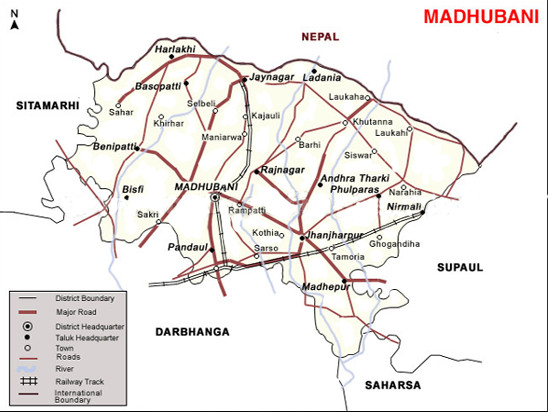 Pisciculture is known to be one of the main sources of revenue in the district. Madhubani is popular world over for its art and crafts. Madhubani Paintings claim a distinct identity because of their unique design and top quality texture. Seen as motifs on bags and dress apparels, Madhubani Paintings are done with utmost care and attention by using vegetable dyes.The district, intersected by kamala and bhutani balaan rivers, is flourishing every year with its farming endeavors and artistic richness.The word “Madhuban” means “Forest of honey” from which Madhubani is derived, but some time it is also known as “madhu”+”vaanri” means “sweet” “voice/language”, as the language of this area is peep to listen,so the name “madhubani” came into picture
How To Reach
By Airport :-
The nearest airport, Lok Nayak Jayaprakash Narayan International Airport,Patna, is 166 kilometers from Madhubani
By Rail :
Madhubani is strategically located on broad gauge railway between Darbhanga and Jaynagar, Darbhanga to Nirmali and Darbhanga to Laukaha on East Central Railway.
By Road :-
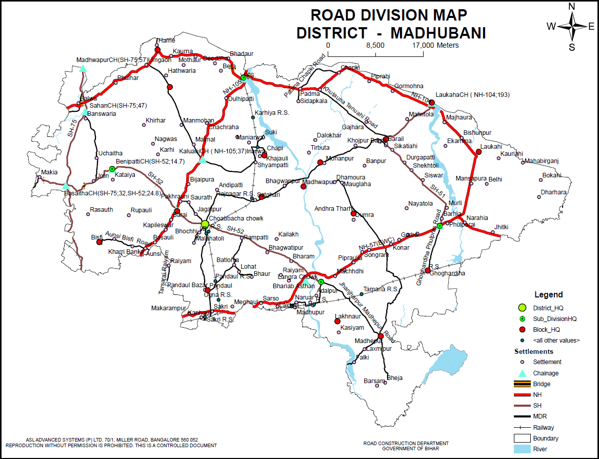 Well connected to other city through National Highway -57(EWC),104,105 SH- 51,52,75 Other road – Khutauna Tenuahi Road,Jhanjharpur Madhepur Road,Aunsi Bisfi Road,Padma Chapki Road,Ghoghardiha Phulparas Road,Tarsarai RaiyamA bus Depot of the Bihar State Road Transport Corporation is also functioning at the district headquarter. Before that private buses used to ply in major parts of the district.
Madhubani is located 162 kilometers from the state capital Patna.
Popular tourist destinations
RAHIKA (MADHUBANI) BLOCK
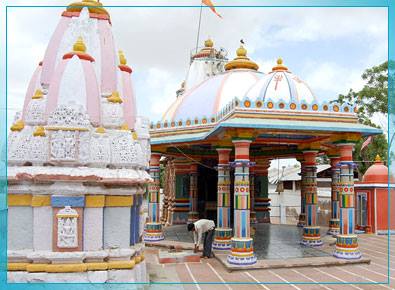
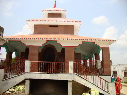
Kali Mandir(Ganga Sagar Pond):-
 Kali Mandir & Ganga Sagar pond were constructed by Maharaja of Darbhanga Late Maharajadhiraj Kameshwar Singh.
Mahesh sthan (Parjuar dih tola)
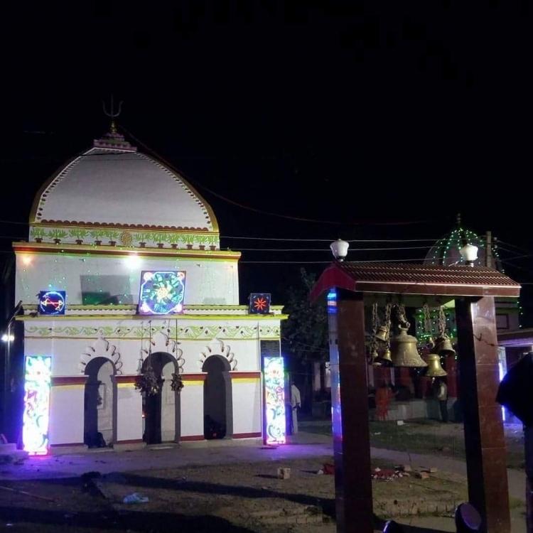
Sankat Mochan Mandir:-
Ugra Mahadev Mandir :-
Shiva Temple (Baswaria):-
Kali Mandir(Bhauara):-
Chandrasenpur:- As per exploration done by KP Jayaswal Research Institute marked Period of site as Early medieval. Garokhar Dih:- As per exploration done by KP Jayaswal Research Institute marked Period of site as Early medieval. Satlakha Dih Tol:- As per exploration done by KP Jayaswal Research Institute marked Period of site as NBPW phase. Rahika Dih:– As per exploration done by KP Jayaswal Research Institute marked Period of site as NBPW phase. Jagat:- As per exploration done by KP Jayaswal Research Institute marked Period of site as NBPW phase. Sugauna:- As per exploration done by KP Jayaswal Research Institute marked Period of site as Early medieval.
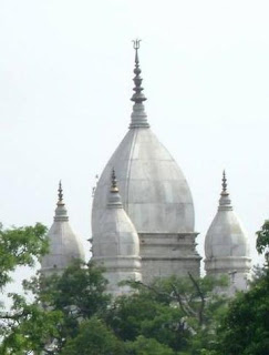
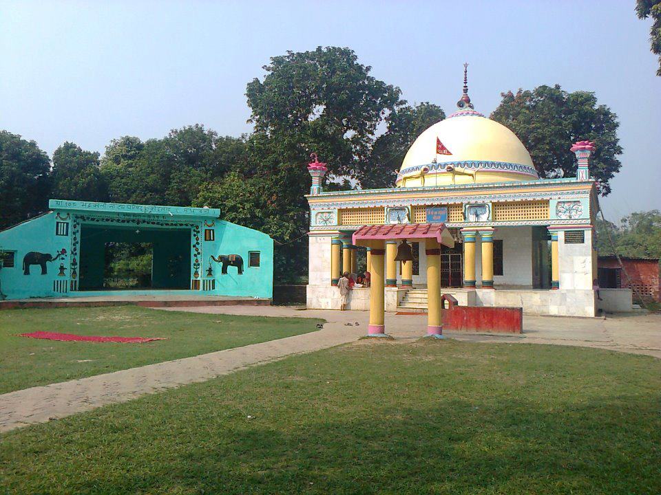
Saurath :-
This is a road side village on Madhubani-Jaynagar road about six Kilometers north east of Madhubani town and contains a temple known as Somnath Mahadev. There is an interesting story which links Saurath to Somnath Temple In Dwarka, Gujarat. According to folk tradition, in AD 1025, Mahmud of Ghazni attacked the famous temple of Somnath, looted the fabulous wealth of the temple, and destroyed it completely. It is believed that Lord Somnath appeared in the dream of the two Maithil Brahman brothers, Bhagirathdutta Sharma and Gangadutta Sharma, and asked them to take His lingam away. The two brothers, following God’s instruction, went to Dwarka and brought the lingam to Saurath and kept the lingam in hiding for a long time. Later the lingam was duly enshrined. Somnath temple at Dwarka is situated in a region known as Saurashtra. In the 18th century a Maithil king constructed here the temple of Somnath. This story is mentioned in the introductory chapter of the official District Gazetteer of Darbhanga 1964, by Roy Choudhary.
It owes its importance to the annual Sabha held by Maithili Brahmins for negotiating marriages .The people gathered at Saurath Sabha Gachhi ( orchard ), covering 22 bighas of land that was donated by the Maharaja of Darbhanga, in the Hindu calendar months of Jyestha-Ashadha. Usually it is held for seven to 15 days every year or sometimes twice in a year during the auspicious period (months). This was an important social congregation where the marriages of Maithil boys and girls are fixed up according to the reading of horoscope by the Panjikars . Many Panjikars who keep the genealogical records of the different families reside here and outside. Mithila King Harisinghdeva (1310–1324) introduced Panji Prabandh in Maithila. This applied to Brahimins and Kayasthas. This was considered a major social reform at that time and was enforced through royal patronage and supervision. The Maharaja of Mithila once again sanctioned this idea and accordingly 14 villages were identified to hold such sabhas: Saurath, Khamgadi, Partapur, Sheohar, Govindpur, Fattepur, Sajhaul, Sukhasaina, Akhrarhi, Hemnagar, Balua, Baruali, Samsaul, and Sahsaula. While Saurath maintains the tradition, all other villages have discontinued holding such Sabha.
According to Jayaswal Research Institute Archaeological Explorations this site belongs to Early medieval period.
Ancient site, temple and tank(Saurath):- The village contains two ancient mounds of which the one near the village is in the shape of a cross roughly 70′ x 50′ and about 5′ high. The other mound is situated away and is said to be thickly covered, in parts, with broken bricks and pottery. This latter mound is quite extensive covering an area of about 2.5 sq. kms and the local people say that it represents the remains of an ancient city.
Mithila Lalit Sangrahalaya (Saurath):- It display and preserve the rich heritage of the regins.
Kapileswar Than (Kakroul):-
Kakroul village is noted for its Shiva Temple, also known as Kapileswar Than, situated nine kilometers from Madhubani District Head Quarter. The sanctum of this modern temple is below ground level and contain old tenth- eleventh century sculptural pieces , among which are detect a Vishnu head. A large fair is also held on the occasion of Maha Shivaratri.
Established by Kapil Muni. The proof of the arrival of king Janak and Sita for worship can be taken from Puranas.
According to Jayaswal Research Institute Archaeological Explorations this site belongs to Early medieval.period.
Malangiya Dih:- As per exploration done by KP Jayaswal Research Institute marked Period of site as NBPW phase. Pokhrani (Pokhrauni):- As per exploration done by KP Jayaswal Research Institute marked Period of site as Medieval. Kanail Dih:- As per exploration done by KP Jayaswal Research Institute marked Period of site as Early medieval. Serma Dih:- As per exploration done by KP Jayaswal Research Institute marked Period of site as Early medieval. Mithauli:- As per exploration done by KP Jayaswal Research Institute marked Period of site as Medieval.
Basuara Dih:- It is said that Basuara Dih is 400 years old, made before making Darbhanga as the kingdom.
According to Jayaswal Research Institute Archaeological Explorations this site belongs to Early medieval period.
Marar:- As per exploration done by KP Jayaswal Research Institute marked Period of site as Early medieval. Jitbarpur:– As per exploration done by KP Jayaswal Research Institute marked Period of site as Early medieval. Bhauara Ganga Sagar:- As per exploration done by KP Jayaswal Research Institute marked Period of site as Early medieval. Nazirpur:- As per exploration done by KP Jayaswal Research Institute marked Period of site as Medieval.
Place of Raiput kingdam of Bhara and Gandha(Basudevpur):– It is situated about 16 km east of Madhubani. It is famous for the place of Rajput kingdom of Bhara and Gandha.
BASOPATTI BLOCK
Biratpur:-
Birautpur (garh) Fort :- The village is about 19 kms to the north of Madhubani and contains ruins of a small fort or garh spread over almost two thirds of an acre. Only traces of its walls and rooms were visible till the beginning of this century. Inside, in a hollowed out recess, a cylindrical pillar is seen which the local people worship as Shiva. The local Telis or oilmen claim that Raja Beraut (i.e. King Virata) who flourished at about the time of the Mahabharata war belonged to their caste and had built the fort.
According to Jayaswal Research Institute Archaeological Explorations this site belongs to Early medieval period.
Jaso:- As per exploration done by KP Jayaswal Research Institute marked Period of site as Early medieval. Siriyapur:– As per exploration done by KP Jayaswal Research Institute marked Period of site as Early medieval. Mahthaur:- As per exploration done by KP Jayaswal Research Institute marked Period of site as NBPW phase. Chhatauni:- As per exploration done by KP Jayaswal Research Institute marked Period of site as Early medieval. Loharpatti (Birpur):- As per exploration done by KP Jayaswal Research Institute marked Period of site as Early medieval. Bundel Khand:- As per exploration done by KP Jayaswal Research Institute marked Period of site as Early medieval. Kauaha:- As per exploration done by KP Jayaswal Research Institute marked Period of site as Early medieval. Hathiya Dih (Mansipatti):- As per exploration done by KP Jayaswal Research Institute marked Period of site as Early medieval. Hathapur Parsa:- As per exploration done by KP Jayaswal Research Institute marked Period of site as Medieval. Damu:- As per exploration done by KP Jayaswal Research Institute marked Period of site as Early medieval. Patauna:- As per e xploration done by KP Jayaswal Research Institute marked Period of site as Early medieval. Ghorbanki:- As per exploration done by KP Jayaswal Research Institute marked Period of site as Early medieval. Ghat madhiya:- As per exploration done by KP Jayaswal Research Institute marked Period of site as NBPW phase. Chanan:- As per exploration done by KP Jayaswal Research Institute marked Period of site as Early medieval. Bhagirathpur Patti:-As per exploration done by KP Jayaswal Research Institute marked Period of site as Early medieval. Pachratan:- As per exploration done by KP Jayaswal Research Institute marked Period of site as Early medieval. Kauaha Bhagwanpur:- As per exploration done by KP Jayaswal Research Institute marked Period of site as Early medieval. Sirsagarh:- As per exploration done by KP Jayaswal Research Institute marked Period of site as NBPW phase.
Manmohan:- As per exploration done by KP Jayaswal Research Institute marked Period of site as Medieval.
Manokamana Nath(Manmoha or Fant):-
Kalyaneshwar Sthan (Kalna):- Kalna village is noted for its Shiva Temple, also known as Kalyneshwar Sthan, said to be built by Raja Janak. It is situated 31 KM towards North from District head quarters Madhubani. 5 KM east of Harlakhi, 162 KM from State capital.

Temple premises contains apart from the Main Temple the temples of Anand Bhairav, Kaal Bhairav, Hanumanji and the temple-kutia of Baba Paramhansa.On the eastern side there is a Chandra-Koop (Well), the sacred water of which is used for pouring on Shiva lingam during the Puja by the devotees.There is also a temple of God Vishwakarma outside the temple premises.
Gazetteers of Darbhanga it has been mentioned that the area of Mithila Raj was under the influence of Shaivites and was marked by many Shiva temples and even the town of Janakpur had four gates of entry and all the gates were marked by four Shiva temples in all the four directions named as Kalyaneshwar on the south, Jaleshwar on the west, Kshireshwar on the north and Mittileshwar on the east. Today only Jaleshwar and Kalyaneshwar stand as testimony to this historical fact. Mithila records confirm that God Kalyaneshwar Shiva and Goddess Girija (Parvati) gave darshan to King Mithi, the founder of Mithila Raj and agreed to stay here and protect the kingdom and the king had accepted them as their Kul-Devata and thus the story of Sita visiting Girijasthan (a place close to Kalyaneshwarsthan) everyday and also the first sighting of Ram at Baag Taraag place in the garden of flowers called Phulhar follows.
Mithila Mahatmya (18th century ) describes famous ”Parikarma”, which covers 128 km distance between India and Nepal.There is description of Three Parikarmas as Janakpur –Brihat Parikarma, Madhyama Parikarma and Laghu Parikarma. Madhayam( Middle one) starting from Kachuri village near Dhanusha ( Nepal ) which is 12 km away from Janakpur and camp at 15 important places, of which Kalyaneshwarsthan, Kalna stands as the first camp.The Parikarma ends after 15 days with offering Puja here but the night camp shifts to Bishaul ( Vishwamitra Sthan ) which is 3 kms away.The Dola of Mithila Bihari and Janak Dulari is decorated beautifully and kept on a raised platform with a big flag (dhwaja) around which Bhajans and kirtans are done whole night by the Bhaktas. Saints throng to this place from all over India and Nepal making the occasion more auspicious.
According to Jayaswal Research Institute Archaeological Explorations this site belongs to Medieval period.
Arghaba:- During the exploration in year 74-75 by ASI discovered a numbers of medieval site, several sculpture such as Vishnu, Ganesa, Eka Mukha Siva Linga, Crowned Buddha belonging to late Pal Period was found along the bank of river Kamala and Bachharaja.
According to Jayaswal Research Institute Archaeological Explorations this site belongs to Medieval period.
Bahandei Pokhar (26:32’:: 85:55):- The site is a lake spread over an area of about 6 acres. It is said that it was dug by some demon in one night. .
ANDHRATHARHI BLOCK
Nimaek Tank (Gorgamma):-
Devhar:-
 It is located 24 KM towards East from District head quarters Madhubani. 7 KM from Andhratharhi. 168 KM from State capital Patna.
Devhar village is noted for its Shiva Temple, also known as Muketshwarnath Dham It is situated in fromt of school.
According to Jayaswal Research Institute Archaeological Explorations this site belongs to NBPW phase period.
Pastan:- It is situated 5 km from block headquarter. It has a Mound formed over remains of stupa, revealing brick structures.
According to Jayaswal Research Institute Archaeological Explorations this site belongs to NBPW phase period.
Harina:- It is situated 5 km from block headquarter. Modern temple containing a medieval, four-armed Kali sculpture
According to Jayaswal Research Institute Archaeological Explorations this site belongs to Medieval period.
Andhra:- Andra has a Medieval Temple known as Kamladitya, constructed over an old mound yielding Early medieval, door-jamb; black stone (basalt?) Surya and Vishnu 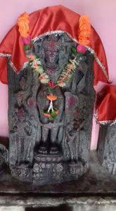 sculptures. The mound about 10 acres is much disturbed but has indication of brick structures and one can also pick up micaceous BRW,NBP and NBP-associated wares. Kamladitya Temple foundation was laid by Sridhar, The minister of Nanya Deva of Karnataka , The first ruler of Mithila.
The temple contains images of Surya, Vishnu,Lakshmi,and Astacal Kamal.The Kamladitya temple signifies both the Sun and Lakshmi-Vishnu.
A stone image, possibly indicating existence of a temple at the spot or in the vicinity, was found here with an inscription on it recording its installation by Sridhara, a minister of Nanya of the Kshatriya family.
Andhra is also the birthplace of the Philosopher Vachaspati Mishra. It consists a chain of 28 pond.
A temple of Maa Bhagwati was constructed by Late L.N.Mishra in year 1982. This place is known as Parmeshwari sthan.
According to Jayaswal Research Institute Archaeological Explorations this site belongs to Medieval period.
Thadhi:- As per exploration done by KP Jayaswal Research Institute marked Period of site as NBPW phase. Harri:- As per exploration done by KP Jayaswal Research Institute marked Period of site as Medieval.
Rakhwari Got:– As per exploration done by KP Jayaswal Research Institute marked Period of site as Early medieval.
Rakhwari :- It is situated 10km away from sub-district headquarter Andhratharhi and 48km away from district headquarter Madhubani.
Miniature bronze image of Buddha and an inscribed eka mukha Siva-linga were found here. (76-77)
Kandarpi Ghat:- It is situated 6 km from block headquarter. A Medieval mound yielding remains of brick structure eroded by the River Kamla is found during exploration done by ASI in Year 2008-09
Gandharaien:- It is situated 3 km away from sub-divisional headquarter. A Medieval Siva Temple is found during exploration done by ASI in Year 2008-09.
PANDAUL BLOCK
Masjid (Sakari chawk):-
Pandaul :- It is situated 1 km south of block headquarter. During the exploration in year 2008-09 by ASI discovered antiquarian remains Medieval Ram-Janaki Temple; marble sculptures of Surya, Durga, Ganesha and Shiva.
Dighiya Pokhar:-It is situated 10 km north-west of block headquarter. During the exploration in year 2008-09 by ASI discovered a Early medieval mound and antiquarian remain red ware potsherds.
Siddeshwari Bhagwati Mandir(Sarisab-Pahi):-
 It is located 18 KM towards South from District head quarters Madhubani. 6 KM from Pandaul. 144 KM from State capital Patna.
Siddheshwari Bhagawati (established by Balram) Temple located at Sarisab is ancient one and Lakshmi Narayan Temple located at Pahi is almost five hundred years old.
The ancient name of Sarisabpahi was Siddharth Kshetra according to Brihad Vishnupuran and Skand Putan.
According to Jayaswal Research Institute Archaeological Explorations this site belongs to Early Medieval period.
Shiva Temple(Navtol):-
 Navtol is a small village of sarisab-pahi west panchayat of Pandaul block. It is located 1.5 kilometera north from National Highway-57 and 17 kilometers south-east from district headquarters. Navtol has a Shiva Temple known as Kalyaneshwar Mahadev.
Ugaranath Temple (Bhawanipur):-
 The Bhawanipur village is located 14 km from Madhubani, 5 kms from the block headquarter of Pandaul and 180 km away from patna. The village is noted for its temple of Ugra Nath and traditional association with famous poet, Vidyapati. As the legend says, Vidyapati was such a great devotee of Lord Shiva that the latter began to serve Vidyapati as his servant named Ugana.
According to Jayaswal Research Institute Archaeological Explorations this site belongs to Early Medieval period.
Hanti:- As per exploration done by KP Jayaswal Research Institute marked Period of site as Early medieval. Haripur:- As per exploration done by KP Jayaswal Research Institute marked Period of site as Early medieval. Tetraha:– As per exploration done by KP Jayaswal Research Institute marked Period of site as Early medieval. Bhagirathpur Dih:– As per exploration done by KP Jayaswal Research Institute marked Period of site as Early medieval. Teliya Dih:- As per exploration done by KP Jayaswal Research Institute marked Period of site as Early medieval. Yamsham Kuna:- As per exploration done by KP Jayaswal Research Institute marked Period of site as Early medieval. Nawada:- As per exploration done by KP Jayaswal Research Institute marked Period of site as NBPW phase. Dharhar:- As per exploration done by KP Jayaswal Research Institute marked Period of site as Early medieval. Mohanpur:- As per exploration done by KP Jayaswal Research Institute marked Period of site as Early medieval. Raghunathpur DihTol:- As per exploration done by KP Jayaswal Research Institute marked Period of site as Early medieval.
Bhagwatipur:- It is located 15 KM towards East from District head quarters Madhubani. 10 KM from Pandaul. 152 KM from State capital Patna.
During the exploration in year 2008-09 by ASI discovered antiquarian remains; Medieval black stone Surya and Agni sculptures, Shiva Temple, situated 1km away from Bhagwatipur and a mound, Early medieval. brick structures (at Kutiptir locality of the village).
According to Jayaswal Research Institute Archaeological Explorations this site belongs to Early Medieval period.
Navahad:- It is situated 13km from District headquater.
During the exploration in year 2008-09 by ASI discovered a Late medieval temple built on an old temple site.
According to Jayaswal Research Institute Archaeological Explorations this site belongs to Medieval period.
Rajegram:- It is situated 6 km away from block headquarter. During the exploration in year 2008-09 by ASI discovered a Medieval Siva Temple.
According to Jayaswal Research Institute Archaeological Explorations this site belongs to Early Medieval period.
Bhaur:- It is situated 10 km away from block headquarter. During the exploration in year 2008-09 by ASI discovered a Medieval temple established in 1556 Saka Samvat (i.e., CE 1634).
LAKHNAUR BLOCK
Akausi:- As per exploration done by KP Jayaswal Research Institute marked Period of site as Early medieval. Balbhadrapur:- As per exploration done by KP Jayaswal Research Institute marked Period of site as Medieval. Lakhnaur:- As per exploration done by KP Jayaswal Research Institute marked Period of site as Early medieval. Nirmala:- As per exploration done by KP Jayaswal Research Institute marked Period of site as Early medieval. Maivi:- As per exploration done by KP Jayaswal Research Institute marked Period of site as Early medieval. Sonbarsa:- As per exploration done by KP Jayaswal Research Institute marked Period of site as Early medieval. Behat:- As per exploration done by KP Jayaswal Research Institute marked Period of site as Early medieval.
Sahni:- It is situated 5 km from block headquarter.During the exploration in year 2008-09 by ASI discovered a Medieval Siva Temple.
Kaitheniya:- It is situated South of Jhanjharpur railway station.During the exploration in year 2008-09 by ASI discovered a Medieval temple.
MADHEPUR BLOCK
Shiva temple,Durga mandir (Dwalakh):- It is located 53 KM towards East from District head quarters Madhubani, 14 KM from Madhepur block headquarter, 166 KM from State capital Patna.
During the exploration in year 2008-09 by ASI discovered antiquarian remains a Medieval temple, named Hareshwar Nath Mandir, situated in an island of the River Kosi in the north side of the village, Painting on inner side of the dome and black stone Shiva-linga and Nandi.
ASI also discovered a Medieval Lakshmi-Narayana Temple situated in the middle of the village , containing black stone sculpture of Vishnu as presiding deity .
There is also a Durgasthan near the village middle school.
Maa Chamunda (Pachahi):-
 It is situated 5 km east of block headquarter and 12 km from Jhanjharpur.Village well known Early medieval. Hindu’s Religious Chamunda Temple constructed over ancient mound. During the exploration in year 2008-09 by ASI discovered antiquarian remains of red ware and terracotta beads of the Early medieval. period.
Bheeth(Bhit) Bhagwanpur:- It is located 46 KM towards East from District head quarters Madhubani, 9 KM south of Madhepur and 156 KM from State capital Patna.
Abhilekh about Mallldev son of Raja Naanyadev is available here.
According to Jayaswal Research Institute Archaeological Explorations this site belongs to Early medieval period
Nawada:- As per exploration done by KP Jayaswal Research Institute marked Period of site as NBPW phase. Barsam:- As per exploration done by KP Jayaswal Research Institute marked Period of site as Early medieval.
Manserpur Dih:- It is situated 10 km from block headquarter.During the exploration in year 2008-09 by ASI discovered a Medieval mound.
Rahua Sangram:- On Madhepur Bheja Road, in the course of exploration done in year 2008-09 by ASI discovered a temple constructed over an ancient mound; remains of medieval temple with bricks; one small sandstone Ganesha sculpture.
Bheja:- It is situated 9 km from block headquarter.During the exploration in year 2008-09 by ASI discovered a Renovated medieval Siva Temple.
HARLAKHI BLOCK
Phoolahar :-
According to Jayaswal Research Institute Archaeological Explorations the Phoolahar site belongs to Early medieval period.
Temple of Goddess Girija (Phoolahar):- The village is situated about 6 kms West of the block headquarters Harlakhi.The village contains the temple of Goddess Girija. It is said that Sita, the daughter of King Janaka, who had his capital at Janakpur close by, used to come to Phulher village, collect sweet-smelling blossoms and offer them to the Girija deity at the temple. The pond called Sarsa Mip pokhara nearby is still pointed out as the pool where Sita would have her bath, sit by and make thegarlands of flower for offering to the deity. Lord Rama saw her for the first time at this place.
Girija temple faces the east. At the entrance, there is a verandah 10 feet by 12 feet. Then there is the cell for the deity, measuring 8 feet by 10 feet.The height of the temple is about 75 feet. The image of the main deity of the temple, the goddess Girija, is about 2 feet high and made of black stone. To the right side of Girija is a two feet image of Janaki, made of marble. To the left side of Girija are the images of Ganeshji (2 feet), Kaliji (2 feet), Durgaji (2 feet), Sri Vishnu (2 feet) and Lord Shiva (21 feet). All these images are of black stone. Excepting the Girija image, the other images were all installed later. To the right side of the Girija temple, there is a temple of Bhairav.
Baag Taraag(Phoolahar):– The Story is as follow that Sita visiting Girijasthan everyday. It is here that one day Sita had repaired with her Sakhi (companion) and Sri Ramachandra had also gone there with Lakshmana and was plucking flowers. The bashful Sita’s eyes fell on Sri Rama- chandra and Sri Ramachandra too was captivated by the coy girl. Both felt a great joy in seeing each other and they hurried back to their respective abodes.
The divine incident of ”love at first sight”sung sweetly in Mithila area rejoices the heart of the followers even today.
Bishaul :- It is the place where Guru Vishwamitra stayed(Vishwamitra’s ashram) with Ram-Lakshman brothers before partaking in the Syvambar Ceremony (Dhanukha Yagyan) at Janakpur.
Vishaul Dih:-
As per exploration done by KP Jayaswal Research Institute marked Period of site as NBPW phase.
Jiraul Dih:- As per exploration done by KP Jayaswal Research Institute marked Period of site as NBPW phase. Kamtaul:-_ As per exploration done by KP Jayaswal Research Institute marked Period of site as NBPW phase. Kalana:- As per exploration done by KP Jayaswal Research Institute marked Period of site as Early medieval. Khirhar:- As per exploration done by KP Jayaswal Research Institute marked Period of site as Early medieval. Sohpur:- As per exploration done by KP Jayaswal Research Institute marked Period of site as Early medieval.
KALUAHI BLOCK
Haripur:- As per exploration done by KP Jayaswal Research Institute marked Period of site as Early medieval.
Dokahar:-
According to Jayaswal Research Institute Archaeological Explorations the Dokahar site belongs to Early medieval period.
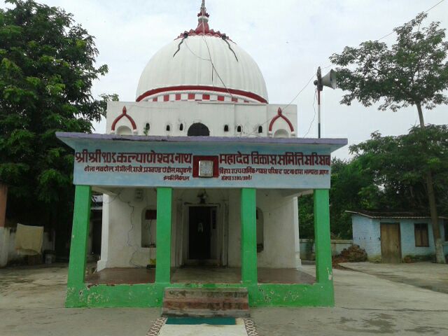
Raj Rajeswari (Dokhar):-
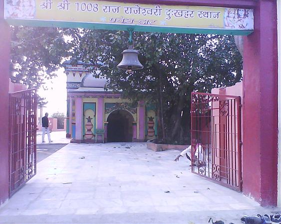 It is situated 12 km north of Madhubani. The sanctum is below ground level. A.C.ninth century image of Uma-Maheshwara has been recovered from the tank associated with this temple and is now in worship.Temple was constructed by Maharaja Maheswar Singh in 1850-60
Bindusar sarobar:- It is the sarobar of Red lotus.
Loha Dih:- As per exploration done by KP Jayaswal Research Institute marked Period of site as Gupta. Kalikapur:- As per exploration done by KP Jayaswal Research Institute marked Period of site as Early medieval. Karmauli:- As per exploration done by KP Jayaswal Research Institute marked Period of site as NBPW phase. Bhalli:- As per exploration done by KP Jayaswal Research Institute marked Period of site as Early medieval. Pursauliya:- As per exploration done by KP Jayaswal Research Institute marked Period of site as Early medieval. Narar:- As per exploration done by KP Jayaswal Research Institute marked Period of site as Early medieval.
BISFI BLOCK
Sohans:– As per exploration done by KP Jayaswal Research Institute marked Period of site as Early medieval. Sakradhi Dih:– As per exploration done by KP Jayaswal Research Institute marked Period of site as Early medieval. Rathaus:– As per exploration done by KP Jayaswal Research Institute marked Period of site as Early medieval. Lohra:- As per exploration done by KP Jayaswal Research Institute marked Period of site as Medieval. Usarahi Dih:- As per exploration done by KP Jayaswal Research Institute marked Period of site as Early medieval. Bherba Dih:- As per exploration done by KP Jayaswal Research Institute marked Period of site as Early medieval. Bhojpandaul:– As per exploration done by KP Jayaswal Research Institute marked Period of site as Early medieval. Baraha:- As per exploration done by KP Jayaswal Research Institute marked Period of site as Medieval. Sasnma Dih:- As per exploration done by KP Jayaswal Research Institute marked Period of site as NBPW phase. Chhachhua Dih:– As per exploration done by KP Jayaswal Research Institute marked Period of site as NBPW phase. Singhiya:- As per exploration done by KP Jayaswal Research Institute marked Period of site as Early medieval. Ghat Bhatra:- As per exploration done by KP Jayaswal Research Institute marked Period of site as Early medieval. Usauthu Dih:- As per exploration done by KP Jayaswal Research Institute marked Period of site as Early medieval.
Bisfi:-
According to Jayaswal Research Institute Archaeological Explorations the Bisfi site belongs to NBPW Phase period.
Birth place of the Vidyapati(Bisfi):- It is 9 km from Kamtaul railway station and 25 km west of Madhuban . It is noted as the birth place of the Maithili poet Vidyapati. The village contains some remnants of his house. The Devi temple in which the poet used to recite hymns and offer prayers also stands. Every year the birthday of poet Vidyapati is celebrated with great enthusiasm. Mythological stories claim that God Mahadev had come down to Bisfi to work as domestic help of Vidyapati.
The maker and hero of a movie on the legendary Maithili poet Vidyapati, Phul Singh has initiated a project to erect a 111 feet high statue of Vidyapati at Vidyapati Dih at village Bisfi in Madhubani district at a cost of about Rs 4 crore by the same sculptor of Delhi, who has been engaged to construct the statue of Sardar Vallabhbhai Patel in Ahmedabad. The entire cost of the project is to be met by Vidyapati Janjagran Trust of which Singh is the chairman. The statue will be erected on the 16-feet high mound on the homestead land of Vidyapati
Murliyachak:- As per exploration done by KP Jayaswal Research Institute marked Period of site as Early medieval. Sisai:- As per exploration done by KP Jayaswal Research Institute marked Period of site as Early medieval.
JAINAGAR BLOCK
Ruins of a mud built fort (Jainagar):- It contains the ruins of a mud built fort. It is probably built by Alauddin Hussain King of Bengal.There are so many temples in Jainagar,out of which two are most famous which are
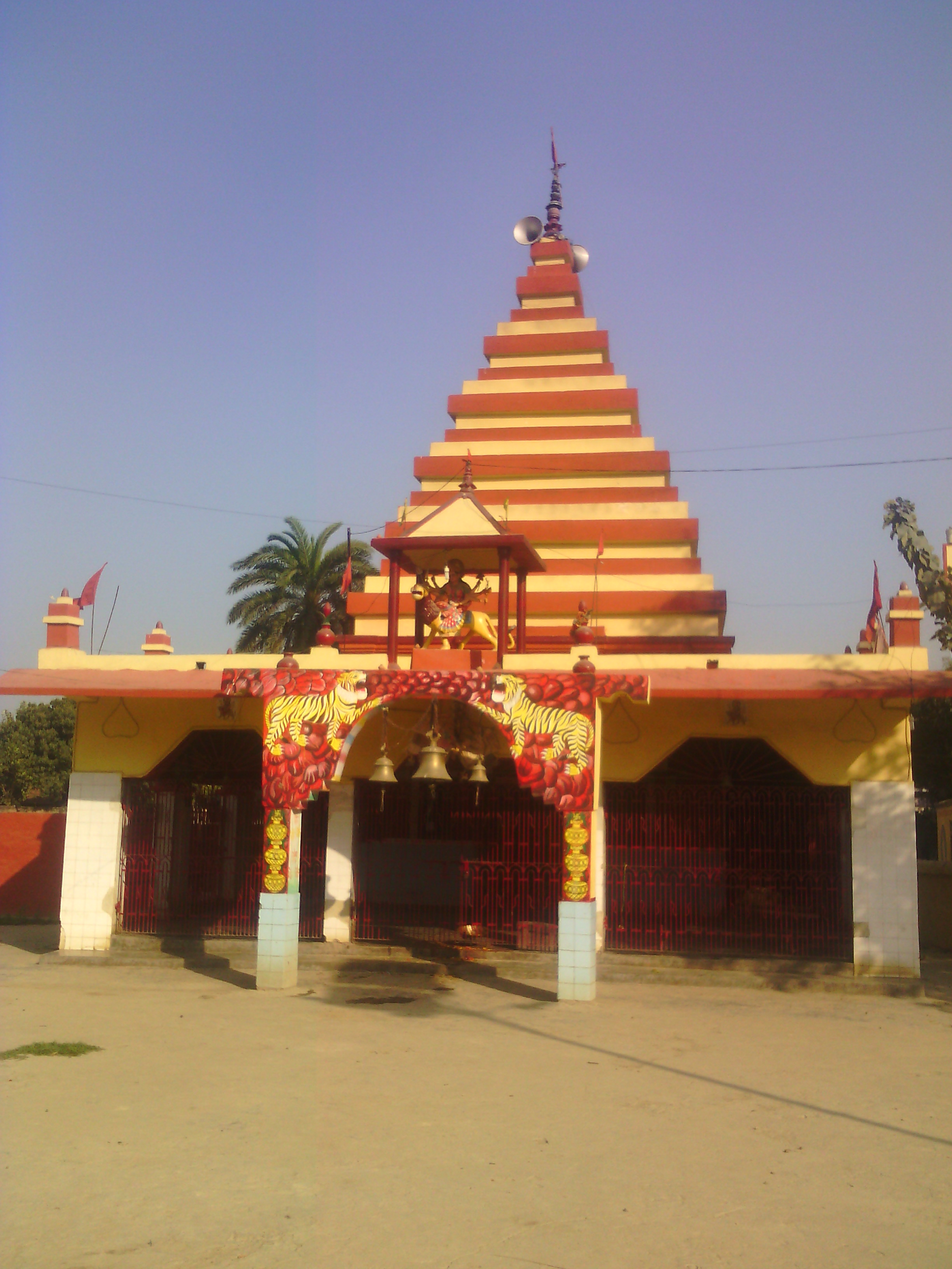
1.Durga mandir-it is 105 ft high and situated 2km away from railway station.
2.Shilanath-it is famous for lord Shiva.it is situated 4 km away from railway station near DV College.
Koria Dih:- As per exploration done by KP Jayaswal Research Institute marked Period of site as NBPW phase. Silkor:- As per exploration done by KP Jayaswal Research Institute marked Period of site as Early medieval.
BABUBARHI BLOCK
Devi Durga Temple(Satghara);-
Baba Mukteswar Nath :- Temple is situated about 3 KM away from Satghara village.
Panchrukhi:- As per exploration done by KP Jayaswal Research Institute marked Period of site as Early medieval. Khoir Dih:- As per exploration done by KP Jayaswal Research Institute marked Period of site as Early medieval.
Balirajgarh (Balirajpur):- Remains of ancient fort,tradition ascribes the fort of Raja Bali of epic period is situated in village Balirajpur which is about 25 km from north-east of Madhubani. King Bali had defeated King Mangal of Mangalgarh in Samastipur district, whose son was seated at Neulaagarh and Mangal’s sister had a citadel at famous Jaimangalaagarh in Begusarai. King Bali of Balirajgarh defeated all of them.
Punched marked coins and NBPW pottery belonging to Mauryan period have been found here.
Excavation done in year 62-63 by ASI.The defence wall consisted of a mud-brick core with brick encasement, the outer one being four times the width of the inner. The wall was battered and measured 5.18 m at the base and 3.65 m at the top. The fortifications seem to have been built somewhere in the second century B.C and remained in use till the Pala period. Antiquities found during excavation are beads, coins, sunga terracotta plaques , bone objects. Fort revealed remains of a temple also, located on the southern defence wall.
According to Jayaswal Research Institute Archaeological Explorations this site belongs to NBPW phase period.
Baruyar:- As per exploration done by KP Jayaswal Research Institute marked Period of site as Early medieval. Fulabaria:- As per exploration done by KP Jayaswal Research Institute marked Period of site as Early medieval. Bharchaura Dih:- As per exploration done by KP Jayaswal Research Institute marked Period of site as Early medieval.
RAJNAGAR BLOCK
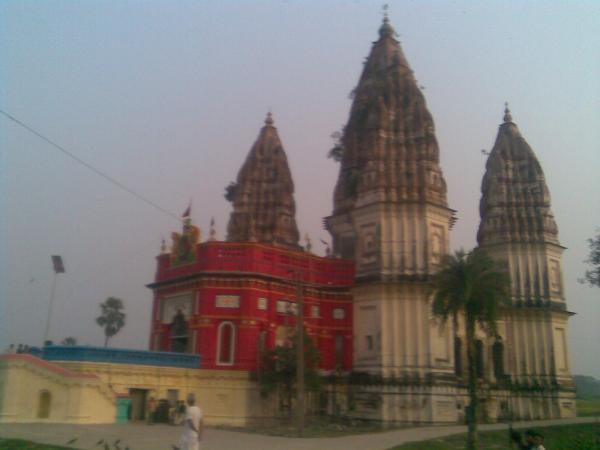
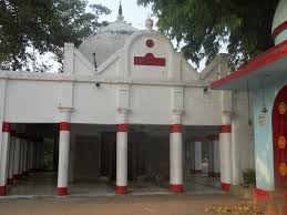
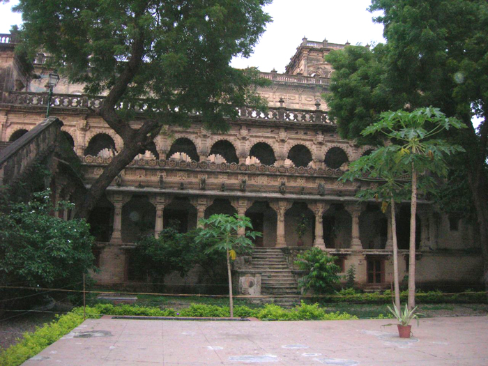
Rajnagar Fort :-Rajnagar is situated at a distance of 15 KM from Madhubani town and is connected by PWD road N.E.Rly. Rajnagar is an another village in Madhubani where 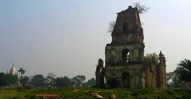 The Raj of Darbhanga established one of his centeres. During the period of King Rameshwar Singh several beautiful buildings and temples were constructed.However, In the earthquake of 1934 most of the building were destroyed but the remains are still worth seeing..The famous temple here are Durga Mandir, Kali Mandir, Kamakhya Mandir, Naulakha Mandir, Shiv Mandir, Girija Mandir.All these Mandirs (temples) were constructed by Maharaja Rameshwar Singh,after the death of his elder brother Maharaja Lakshmeshwar Singh.The property of Rajnagar,Korahiya and Bhowara Garh was donated to Kumar Rameshwar Singh by his elder brother Maharaja Lakshmeshwar Singh.After the death of Maharaja Lakshmeshwar Singh,his younger brother Kumar Rameshwar Singh became Maharaja and all the property donated to him vested in the Raj of Darbhanga.
Ruins of Navlakha Palace of Maharaja of Darbhanga (Rajnagar):-
Naulakha Palace is situated in the Rajnagar town. It is close to the Kamala River. Maharaja Rameshwar Singh of Darbhanga undertook the construction of the Naulakha Palace. The palace was damaged in 1934 due to an earthquake. Now it is Known for ruins of Navlakha Palace.
There is Durga Bhawan towards the entrance of the palace. In front of the Durga Bhawan lies a pond. A temple dedicated to Goddess Kali is located towards the north of the pond. The centre of the Naulakha Palace has a seven storey tower. There is a building having three courtyards in the western side of the Durga Bhawan. A two-storeyed white coloured palace of the Bari Maharani is located towards the north of the building. Another pond is located north of the Maharani’s Palace, surrounded by garden on three sides.
The Gosauni Ghar, which means the room of the deities, can also be seen within the palace. The palace of Chhoti Maharani lies close to the room of the deities. Another temple in the palace is dedicated to Goddess Tripura Sundari and has many paintings of the Goddess. Abdul Gani made a beautiful painting of Goddess Tripura Sundari.
Raj Mandir (Rajnagar):-
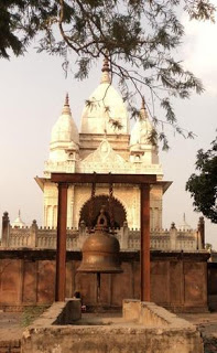
 The site has Renovated medieval Kali Mandir, Durga temple, Temple of Hanuman and a very large Shiv temple . The Shiv temple has a very big bell and Nandi in front of it .These were built by Maharaja of Darbhanga in nineteenth century.
Palibar:- As per exploration done by KP Jayaswal Research Institute marked Period of site as Early medieval. Raghubir chak:- As per exploration done by KP Jayaswal Research Institute marked Period of site as Early medieval. Raghopur:- As per exploration done by KP Jayaswal Research Institute marked Period of site as Medieval. Shriganj:- As per exploration done by KP Jayaswal Research Institute marked Period of site as Early medieval.
Bhadra Kali Mandir(Koilakh):-
It is situated 10km away from sub-district headquarter Rajnagar and 12km away from district headquarter Madhubani and 155 KM from State capital Patna, consists Late medieval temples of Bhagwati, Mahadeva and LakshmiNarayana.
According to Jayaswal Research Institute Archaeological Explorations this site belongs to Early Medieval period.
Badahi:- As per exploration done by KP Jayaswal Research Institute marked Period of site as Medieval. Raghuni Dehat dih:- As per exploration done by KP Jayaswal Research Institute marked Period of site as Early medieval. Rampati:- As per exploration done by KP Jayaswal Research Institute marked Period of site as Early medieval. Kusahi Dih (Belhabar):- As per exploration done by KP Jayaswal Research Institute marked Period of site as Early medieval.
Shri Shri 1108 Ekadash Rudra Mahadeva temple (Mangrauni):-In 17th century a great astrologer and tantrik was born in mithila, whose name was Pundit Madan Mohan Upadhyay. During the period in question the ruler of Madhubani was Kharore Raja. It’s capital was village Bhaura near Madhubani. Pundit Madan Mohan Upadhyay visited Raj durbar whenever Raja required his services. One day when he was sitting in the King’s court, the king said that today is Amavasya (New Moon). All the pundits of the durbar agreed, But Pundit Upadhyay was thinking about something else, and when the king asked the same question to him he replied with a NO and said it was a full moon night, all the pundits and the king laughed at this answer and asked if he can prove this. Pundit Ji replied affirmatively “Yes Sir!”. When pundit ji reached home he realized that he is wrong as it is Amavasya today. He went to his own temple and prayed to the Goddess, it is said that the goddess, enlightened the sky through her kangana (Bangle) in the sky became so bright that the original moon light was disappeared in the light of Kangana and it gave the look of Full moon Night. From Then onwards the king never laughed on any answer of Pundit ji again.Pundit Madan Mohan Upadhyay who was the first famous man of mangroni was by instinct a great Tantrik and it was said that he used to go to kamrup kamakhya every morning by sky route and come back by afternoon. It was his daily routine. One day his younger son also went to kamakhya with him but some yogini of kamakhya saw the young and smart boy and fell in one sided love with him. It was the time of dussehra (durga puja). Pandit upadhyaya as usual went to worship the Goddess, in the meantime yogini starting to suck his son out by evil mantras. His son was surprised and told his father that some external forces were throwing him outside the temple .
Pandit ji instructed his son to catch the idol of the Goddess, but the young boy said again that even the goddess’s idol was being pulled outside the temple. the pandit ji laughed and said that you forget the idol and catch my leg. When the young boy caught his father’s leg every thing started coming into order. It is said that the Goddess said to the pundit ji that he need not personally come to kamakhya again and even your family members were not required to see me here. She asked Pundit Ji to go to Mangrauni and get a pond dug there in your campus at mangrauni. She assured that she will appear in the shape of yantra from the pond. She asked him to perform the Pooja of the yantra everyday. pandit ji came back to mangroni and instructed to dig a pound as the Goddess said. Goddess appeared in the shape of yantra in the pond and pundit ji started worshipping the goddess every day. Now a days this mandir is known as Budhi maa Durga Asthan in Mangrauni.
According to Jayaswal Research Institute Archaeological Explorations this Mangrauni site belongs to Medieval period.
Karaiya:- As per exploration done by KP Jayaswal Research Institute marked Period of site as Early medieval. Balaha Dih:- As per exploration done by KP Jayaswal Research Institute marked Period of site as Medieval Meran:- As per exploration done by KP Jayaswal Research Institute marked Period of site as Medieval. Ekamma Dih:- As per exploration done by KP Jayaswal Research Institute marked Period of site as Medieval. Chataila Dih:- As per exploration done by KP Jayaswal Research Institute marked Period of site as Medieval. Chapahi Garh:- As per exploration done by KP Jayaswal Research Institute marked Period of site as Early medieval.
MADHWAPUR BLOCK
Sunphulwa (Uttara):- As per exploration done by KP Jayaswal Research Institute marked Period of site as Early medieval. Dumra:- As per exploration done by KP Jayaswal Research Institute marked Period of site as Medieval. Salempur:- As per exploration done by KP Jayaswal Research Institute marked Period of site as Early medieval. Saharghat Garh:- As per exploration done by KP Jayaswal Research Institute marked Period of site as Early medieval.
LADANIA BLOCK
Nandarhi:- As per exploration done by KP Jayaswal Research Institute marked Period of site as Early medieval. Dharharha Dih (Padma):– As per exploration done by KP Jayaswal Research Institute marked Period of site as Early medieval. Harhi Dih:- As per exploration done by KP Jayaswal Research Institute marked Period of site as Early medieval.
JHANJHARPUR BLOCK
Tomb of Makhdu Shah Jahaniyan:- The people of India, Nepal, Bhutan comes and demand their votive after completing the same they come with the votive-offers as they promise to Baba Makhdum Shah Jahaniyan. It is wonderful in itself. Dargah mela is also very famous.
Durga Mandir (Navtola jhanjharpur):-
 It is situated near south of Railway station.
Road cum Rail bridge(Janjharpur):-
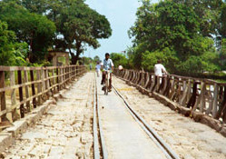 A 220ft bridge passing over the river was constructed by the British in early 1900s. The century-old bridge facilitates the movement of trains and vehicles every day to and from Jhanjharpur. Rickshaws, trucks and cars jostle for space on the bridge, everything comes to a halt at the railway gates when trains arrive, only to trail them in close proximity.
Jhanjharpur:-
As per exploration done by KP Jayaswal Research Institute marked Period of site as Early medieval.
Nathunni manndir(Machhdhi):- It is also called as Mahadev asthan.
Lohna:- As per exploration done by KP Jayaswal Research Institute marked Period of site as Early medieval.
Jamuthari:–
During the exploration in year 1976-77 by ASI discovered Surya, Vishnu, In black basalt.
According to Jayaswal Research Institute Archaeological Explorations this site belongs to Late medieval period.
Gauri Shankar Sthan(Jamuthari):- An ancient combined statu of Gauri and Shankar here
Jalpayi Dih:- As per exploration done by KP Jayaswal Research Institute marked Period of site as Medieval. Gadhauli Dih:- As per exploration done by KP Jayaswal Research Institute marked Period of site as Early medieval. Lachhmipur:- As per exploration done by KP Jayaswal Research Institute marked Period of site as Early medieval. Jamdhar Dih:- As per exploration done by KP Jayaswal Research Institute marked Period of site as Early medieval. Parasa:- As per exploration done by KP Jayaswal Research Institute marked Period of site as Medieval. Madanpur:- As per exploration done by KP Jayaswal Research Institute marked Period of site as Early medieval. Gadhiya Musahari (Naruar):- As per exploration done by KP Jayaswal Research Institute marked Period of site as Early medieval. Sukhet Dih:- As per exploration done by KP Jayaswal Research Institute marked Period of site as NBPW phase.
Bideshwar Asthan:-
 It is famous for the old temple of Lord Shiva known as Bideshwar Sthan. It is believed that the deity was installed by Shri Bindeshwar Thakur, the great grandfather of the renowned poet Vidyapati. Around the temple there are various carvings of black stone. It is also believed to have been the seat of Deobansi Raias , remains of whose fortress still exist in the heart of the village.
Statue of five gods of the 10th century AD , a statue of lord Vishnu was also found . Besides it has a statue of lord Buddha of 12th century was also found here in earth touching pose.
In the course of exploration done in year 2008-09 by ASI discovered the following antiquarian remains such as Surya, Siva-Parvati in black stone (basalt?) and one door-jamb depicting life cycle of a man in sandstone.
According to Jayaswal Research Institute Archaeological Explorations this site belongs to Early medieval period.
Wali Dih (Mahinathpur):- As per exploration done by KP Jayaswal Research Institute marked Period of site as Medieval. Mohrail:- As per exploration done by KP Jayaswal Research Institute marked Period of site as Medieval.
BENIPATTI BLOCK
Atrauli:- As per exploration done by KP Jayaswal Research Institute marked Period of site as Early medieval. Kushmaul:- As per exploration done by KP Jayaswal Research Institute marked Period of site as Early medieval. Aunkli:- As per exploration done by KP Jayaswal Research Institute marked Period of site as Early medieval. Jhonjhi:- As per exploration done by KP Jayaswal Research Institute marked Period of site as Early medieval. Navkarhi:- As per exploration done by KP Jayaswal Research Institute marked Period of site as Early medieval. Mahmadpur:– As per exploration done by KP Jayaswal Research Institute marked Period of site as Early medieval. Parsauna Jarail:- As per exploration done by KP Jayaswal Research Institute marked Period of site as Early medieval. Pali Dih:- As per exploration done by KP Jayaswal Research Institute marked Period of site as NBPW phase. Dhakjari:- As per exploration done by KP Jayaswal Research Institute marked Period of site as Medieval. Sugauta Dih (Pauman):- As per exploration done by KP Jayaswal Research Institute marked Period of site as Medieval. Damodarpur:- As per exploration done by KP Jayaswal Research Institute marked Period of site as Early medieval. Durgauli:- As per exploration done by KP Jayaswal Research Institute marked Period of site as Early medieval. Pauam Dih:- As per exploration done by KP Jayaswal Research Institute marked Period of site as Early medieval.
Uchaith :-Village is located about 45 km north-west of Darbhanga railway station. There is a modern ancient temple of Durga on the western bank of river Tumne. Local legends widely prevalent in Mithila associate Kalidasa, the immortal poet in the court of ancient Ujjain, with Uchaitha during his early years as a student.This conduct of his enraged them  and they made a complaint to their Guru that Kalidasa, who was considered to be a very dull student,disturbed them in their studies. The Guru called him and asked as to why he was misbehaving. Kalidasa promptly replied in an unusual way that he could not tolerate the wrong pronunciation of his class fellows.The, Guru, to his utter surprise, found that the boys had erred in their pronunciation and that Kalidasa was fully justified in pointing out their mistakes.He asked Kalidasa about this sudden development of great intellect in him. Kalidasa narrated the story of the previous night when he had the privilege of meeting the goddess Durga, who had appeared before him and gave him the blessing of wonderful learning. For this very divine achievement the place is called Siddha Pitha of Kalidasa.
There is a slight variation to the story. Some say that the goddess Kali who was visited at midnight blessed Kalidasa. It is said that no one could dare to visit the temple of Kali at midnight, as he would be dead by such a visit. The boys at the pathshala wanted to test the courage of Kalidasa and asked him to visit the temple at midnight. Kalidasa did this and the goddess, being pleased with his courage, blessed him that lie would be a great scholar.It may be mentioned here that Durga and Kali are the manifestations of Mahasakti. Kalidasa ultimately became the court poet of Vikramaditya who was known as Chandra Gupta II.
The temple faces the east. It has a round dome. The temple is on the edge of a tank.The temple appears to be a recent structure. At the entrance to the temple there is a verandah . Above this there is a room for the goddess Durga which is about 8 feet by 10 feet.There is also an image of the goddess Durga in black stone about 2 feet high. A lotus flower can be seen on the back of a lion and tile goddess is sitting on it.There is Brahma on the left and Moon on the right side. There is an image, 6 inches high, of the goddess Kali, on the left side of the goddess Durga. All the four arms of the goddess Durga are cut off and the head is missing. The image is said to have been desecrated. Some small images of Ganesha, Shiva, Vishnu, Lakshmi and Hanuman are on the right side of the goddess Durga. They are of black stone.
It is said that the late Maharajadhiraja Sir Rameshwar Singh of Darbhanga had expressed his desire to reinstate the head of the image. Accordingly, an order was placed and the head was carved out. Before the installation of the head he had a dream in which the goddess told him, ”I am the creator and you want to create my head. Do you think it is proper for you to create my head.”The Maharajadhiraja was upset. The Mahantha of Uchaitha temple had also the same dream. At last it was decided that the head should not be installed.The priests of the temple took the head from the Maharajadhiraja and kept it near the image to offer it the usual offerings. The stone head is still lying in the temple precincts.
A few years ago, the tank was cleaned and a number of images were found. All of them were removed to the Patna Museum.
In front of the temple of the goddess Durga there is newly constructed a temple of Lord Shiva. There is also a small temple of Bhairava in the rear side of the Shiva temple. Just below these temples flows the river Kamla.
On the other side of the river, towards the south-east of the temple, is the site of what is believed to be the Pathshala of Kalidasa. In local dialect and survey records it is mentioned as Kaildasko Chaupdi i.e., the college of Kalidasa. Chaupdi is derived from the Sanskrit word Chatushpathi i.e., where the four Vedas are read and taught.
It is an elevated piece of ground measuring about one bigha in area.So far as the architecture is concerned, the temple is reconstructed in the Indo-Aryan style. There is a square cella for the image. It is curvilinear and there is no trace of storeys and the massive circular coping stone i.e., amalaka, on which the kalasa has been put, surmounts it.
According to Jayaswal Research Institute Archaeological Explorations this site belongs to Early Medieval period.
Manapur:-During the exploration in year 74-75 by ASI discovered a numbers of medienal site, several sculpture such as Vishnu, Ganesa, Ekdmukha Siva Linga, Crowned Buddha belonging to late Pal Period was found along the bank of river Kamala and Bachharaja.
Shivanagar:- As per exploration done by KP Jayaswal Research Institute marked Period of site as Medieval. Devpura Dih:- As per exploration done by KP Jayaswal Research Institute marked Period of site as Early medieval. Benipatti Garh:- As per exploration done by KP Jayaswal Research Institute marked Period of site as Medieval. Paraul:- As per exploration done by KP Jayaswal Research Institute marked Period of site as Medieval. Bankata:- As per exploration done by KP Jayaswal Research Institute marked Period of site as Medieval. Kapsiya Dih:- As per exploration done by KP Jayaswal Research Institute marked Period of site as Early medieval. Narhi Dih:- As per exploration done by KP Jayaswal Research Institute marked Period of site as Early medieval. Kaiuth Garh:- As per exploration done by KP Jayaswal Research Institute marked Period of site as Early medieval. Muret:- As per exploration done by KP Jayaswal Research Institute marked Period of site as Early medieval. Akaur Dih:- As per exploration done by KP Jayaswal Research Institute marked Period of site as Early medieval.
Nagdah:-
Nagdah is surrounded by four lakes. Nagdah village contains the Bhagwati Temple.
According to Jayaswal Research Institute Archaeological Explorations this site belongs to Early medieval.
Bijalpura:- As per exploration done by KP Jayaswal Research Institute marked Period of site as Early medieval. Nakarhi:- As per exploration done by KP Jayaswal Research Institute marked Period of site as Early medieval. Barri (Chaugama):- As per exploration done by KP Jayaswal Research Institute marked Period of site as Late medieval. Shahpur:– As per exploration done by KP Jayaswal Research Institute marked Period of site as Late medieval. Ahpur:- As per exploration done by KP Jayaswal Research Institute marked Period of site as Early medieval.
Akaura :-
It is situated about 7 km north of Benipatti. There is scattered mounds spread over about 1 km. Dilip.K.C.found a modern temple and its adjecent area contains Pal period Vishnu image of ninth – twelfth centuar A.D. This is also ceramic evidence of the early centuries A.D.
KHUTAUNA BLOCK
Hathiyahi:- As per exploration done by KP Jayaswal Research Institute marked Period of site as Early medieval.
Maharani Pokher(kanhauli):-
LAUKAHI BLOCK
PHULPARAS BLOCK
Durgasthan(Baika):- It is situated in Mahindra Panchyat under Phulparas sub-division. During the construction of NH57 in a pond, Granite made statue of god Narsingh was found and kept in Durgasthan.
In 1957 during excavation done in pond the Joint statue of Shiva parvati, one Sivaling, Bhayrabnath , black ancient stone were found which are enshrined in Durgasthan.
Jageshwar sthan(Hullaspatti):- It is located 46 KM towards East from District head quarters Madhubani, 1/2 KM from Ghoghardiha and 178 KM from State capital Patna
There is an image of the God Vishnu in black stone.
unknow block
Kachhora :- In the course of exploration done by ASI in year 1982-83 discovered a large mound in Kachhora village, yielding red and medieval glazed wares .